Kärkölä elevation
Kärkölä (Uusimaa, Helsinki), Finland elevation is 132 meters and Kärkölä elevation in feet is 433 ft above sea level [src 1]. Kärkölä is a populated place (feature code) with elevation that is 55 meters (180 ft) bigger than average city elevation in Finland.
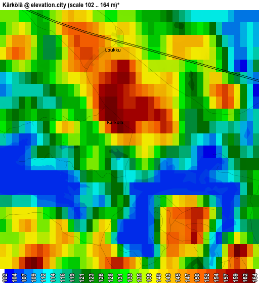
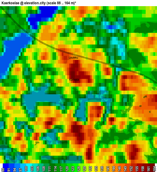
Below is the Elevation map of Kärkölä, which displays elevation range with different colors. Scale of the first map is from 102 to 164 m (335 to 538 ft) with average elevation of 128.4 meters (=421 ft) [note 1]
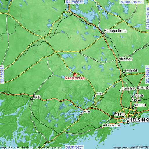
These maps also provides idea of topography and contour of this city, they are displayed at different zoom levels. More info about maps, scale and edge coordinates you can find below images.
| \ | Map #1 | Map #2 | Topo.Map |
| Scale [m] | 102..164 m | 88..164 m | × |
| Scale [ft] | 335..538 ft | 289..538 ft | × |
| Average | 128.4 m = 421 ft | 125.6 m = 412 ft | × |
| Width | 4.8 km = 3 mi | 9.59 km = 6 mi | 153.5 km = 95.4 mi |
| Height | 4.8 km = 3 mi | 9.59 km = 6 mi | 153.4 km = 95.3 mi |
| ↑Max Latitude | 60.634477° | 60.65602° | 61.29563° |
| Latitude at center | 60.61292° | 60.61292° | 60.61292° |
| ↓Min Latitude | 60.591349° | 60.569763° | 59.91545° |
| ← Min Longitude | 23.898015° | 23.854069° | 22.53571° |
| Longitude center | 23.94196° | 23.94196° | 23.94196° |
| →Max Longitude | 23.985905° | 24.029851° | 25.34821° |
Nearby cities:
Cities around Kärkölä sort by population:
• Vihti elevation 39 m
30 km,  136°
136°
• Forssa 133 m
28.4 km,  322°
322°
• Somero 93 m
22.3 km,  271°
271°
• Karkkila 74 m
17 km,  120°
120°
• Loppi 122 m
30 km,  67°
67°
• Tammela 119 m
23.9 km,  336°
336°
• Jokioinen 122 m
32.7 km,  309°
309°
• Renko 111 m
36.6 km,  30°
30°
• Kiikala 115 m
26.2 km,  231°
231°
• Suomusjärvi 105 m
33.3 km,  208°
208°
• Sammatti 59 m
33.2 km,  191°
191°
• Saukkola 50 m
25.6 km,  174°
174°
Multilingual:
 En español:
Kärkölä elevación 132 m.
 En France:
Kärkölä élévation 132 m.


Sources and notes:
- [note 1] Map square and city borders are not equal. Map elevation data is calculated only from area inside that square.
- [src 1] Elevation data from geonames database provided with same terms of usage.
- [src 2] The elevation map of Kärkölä is generated using GMTED2010 database with 7.5 arcsec (225m) resolution.
- [src 3] Base (background) map © OpenStreetMap contributors tiles are generated by Geofabrik and OpenTopoMap.
Copyright & License:
This Kärkölä Elevation Map is licensed under CC BY-SA. You may reuse any part from this page, if you give a proper credit by linking to this URL:
 More info on terms of use page.