Kerava elevation
Kerava (Uusimaa, Helsinki), Finland elevation is 54 meters and Kerava elevation in feet is 177 ft above sea level [src 1]. Kerava is a seat of a third-order administrative division (feature code) with elevation that is 23 meters (75 ft) smaller than average city elevation in Finland.
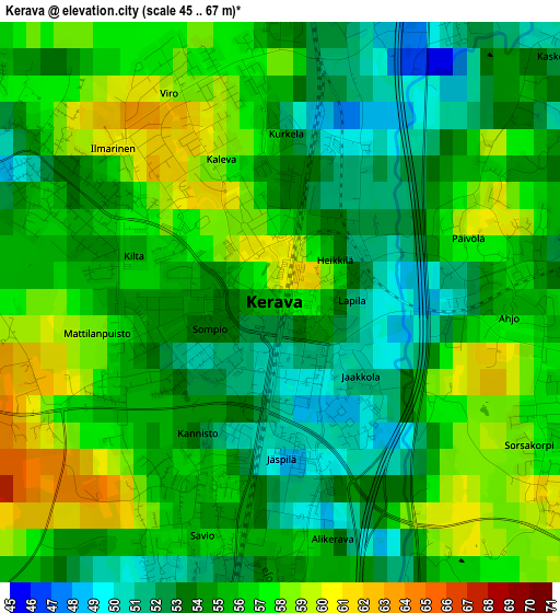
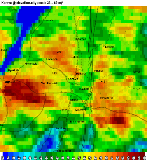
Below is the Elevation map of Kerava, which displays elevation range with different colors. Scale of the first map is from 45 to 67 m (148 to 220 ft) with average elevation of 54.9 meters (=180 ft) [note 1]
These maps also provides idea of topography and contour of this city, they are displayed at different zoom levels. More info about maps, scale and edge coordinates you can find below images.
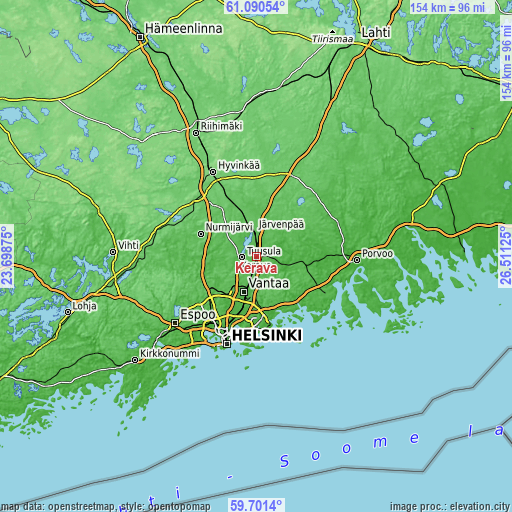
| \ | Map #1 | Map #2 | Topo.Map |
| Scale [m] | 45..67 m | 33..69 m | × |
| Scale [ft] | 148..220 ft | 108..226 ft | × |
| Average | 54.9 m = 180 ft | 51.4 m = 169 ft | × |
| Width | 4.83 km = 3 mi | 9.65 km = 6 mi | 154.5 km = 96 mi |
| Height | 4.83 km = 3 mi | 9.65 km = 6 mi | 154.4 km = 95.9 mi |
| ↑Max Latitude | 60.425077° | 60.446759° | 61.09054° |
| Latitude at center | 60.40338° | 60.40338° | 60.40338° |
| ↓Min Latitude | 60.381669° | 60.359943° | 59.7014° |
| ← Min Longitude | 25.061055° | 25.017109° | 23.69875° |
| Longitude center | 25.105° | 25.105° | 25.105° |
| →Max Longitude | 25.148945° | 25.192891° | 26.51125° |
Nearby cities:
Cities around Kerava sort by population:
• Vantaa elevation 18 m
12.6 km,  196°
196°
• Järvenpää 51 m
7.9 km,  353°
353°
• Nurmijärvi 78 m
17.7 km,  292°
292°
• Mellunkylä 19 m
18.9 km,  180°
180°
• Vuosaari 6 m
21.6 km,  174°
174°
• Tuusula 58 m
4.3 km,  270°
270°
• Kallio 30 m
25.8 km, 199°
• Kaarela 35 m
20.9 km,  216°
216°
• Sibbo 27 m
9.5 km,  107°
107°
• Pornainen 50 m
16.9 km,  61°
61°
• Kellokoski 62 m
14.4 km,  0°
0°
• Nickby 32 m
10 km,  102°
102°
Multilingual:
 En español:
Kerava elevación 54 m.
 En France:
Kerava élévation 54 m.


Sources and notes:
- [note 1] Map square and city borders are not equal. Map elevation data is calculated only from area inside that square.
- [src 1] Elevation data from geonames database provided with same terms of usage.
- [src 2] The elevation map of Kerava is generated using GMTED2010 database with 7.5 arcsec (225m) resolution.
- [src 3] Base (background) map © OpenStreetMap contributors tiles are generated by Geofabrik and OpenTopoMap.
Copyright & License:
This Kerava Elevation Map is licensed under CC BY-SA. You may reuse any part from this page, if you give a proper credit by linking to this URL:
 More info on terms of use page.