Kokemäki elevation
Kokemäki (Satakunta, Pori), Finland elevation is 42 meters and Kokemäki elevation in feet is 138 ft above sea level [src 1]. Kokemäki is a seat of a third-order administrative division (feature code) with elevation that is 35 meters (115 ft) smaller than average city elevation in Finland.
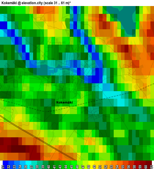
Below is the Elevation map of Kokemäki, which displays elevation range with different colors. Scale of the first map is from 31 to 61 m (102 to 200 ft) with average elevation of 44.7 meters (=147 ft) [note 1]
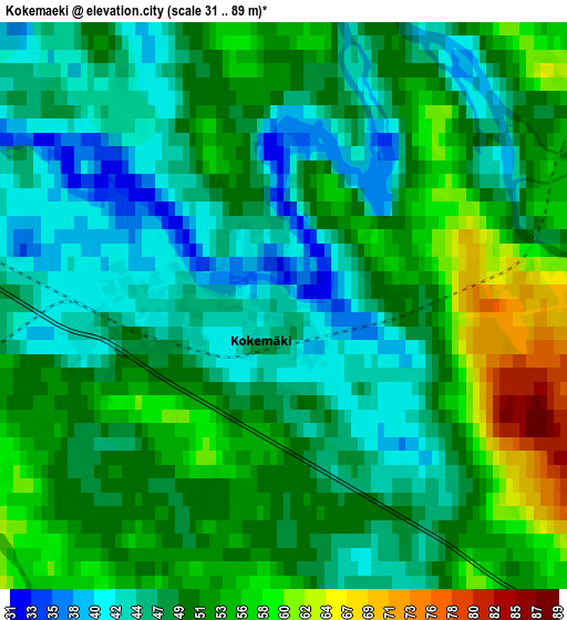
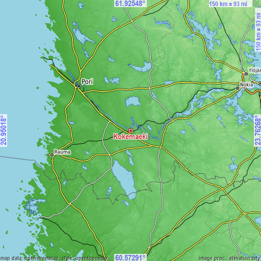
These maps also provides idea of topography and contour of this city, they are displayed at different zoom levels. More info about maps, scale and edge coordinates you can find below images.
| \ | Map #1 | Map #2 | Topo.Map |
| Scale [m] | 31..61 m | 31..89 m | × |
| Scale [ft] | 102..200 ft | 102..292 ft | × |
| Average | 44.7 m = 147 ft | 49.6 m = 163 ft | × |
| Width | 4.7 km = 2.9 mi | 9.4 km = 5.8 mi | 150.4 km = 93.5 mi |
| Height | 4.7 km = 2.9 mi | 9.4 km = 5.8 mi | 150.4 km = 93.5 mi |
| ↑Max Latitude | 61.277596° | 61.298707° | 61.92548° |
| Latitude at center | 61.25647° | 61.25647° | 61.25647° |
| ↓Min Latitude | 61.23533° | 61.214176° | 60.57291° |
| ← Min Longitude | 22.312485° | 22.268539° | 20.95018° |
| Longitude center | 22.35643° | 22.35643° | 22.35643° |
| →Max Longitude | 22.400375° | 22.444321° | 23.76268° |
Nearby cities:
Cities around Kokemäki sort by population:
• Vammala elevation 68 m
30.3 km,  73°
73°
• Ulvila 5 m
32.2 km,  306°
306°
• Eura 41 m
18.2 km,  221°
221°
• Huittinen 52 m
20.1 km,  113°
113°
• Harjavalta 37 m
13.7 km,  299°
299°
• Nakkila 18 m
22.6 km, 302°
• Äetsä 55 m
17.7 km,  80°
80°
• Säkylä 39 m
24.8 km,  182°
182°
• Kiukainen 36 m
15.3 km,  253°
253°
• Köyliö 47 m
15.5 km,  189°
189°
• Kullaa 35 m
25.9 km,  336°
336°
• Kiikoinen 54 m
24.9 km,  28°
28°
Multilingual:
 En español:
Kokemäki elevación 42 m.
 En France:
Kokemäki élévation 42 m.


Sources and notes:
- [note 1] Map square and city borders are not equal. Map elevation data is calculated only from area inside that square.
- [src 1] Elevation data from geonames database provided with same terms of usage.
- [src 2] The elevation map of Kokemäki is generated using GMTED2010 database with 7.5 arcsec (225m) resolution.
- [src 3] Base (background) map © OpenStreetMap contributors tiles are generated by Geofabrik and OpenTopoMap.
Copyright & License:
This Kokemäki Elevation Map is licensed under CC BY-SA. You may reuse any part from this page, if you give a proper credit by linking to this URL:
 More info on terms of use page.