Kuhmo elevation
Kuhmo (Kainuu, Kehys-Kainuu), Finland elevation is 166 meters and Kuhmo elevation in feet is 545 ft above sea level [src 1]. Kuhmo is a seat of a third-order administrative division (feature code) with elevation that is 89 meters (292 ft) bigger than average city elevation in Finland.
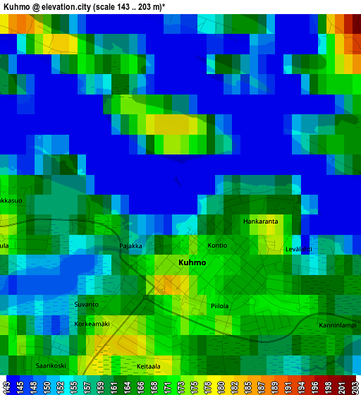
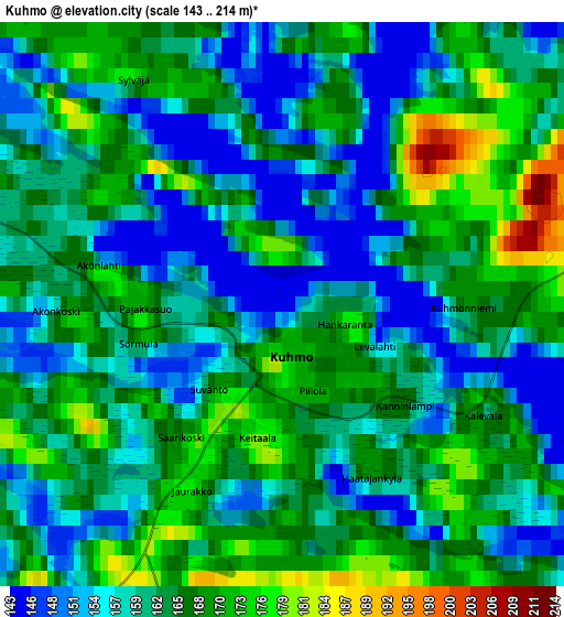
Below is the Elevation map of Kuhmo, which displays elevation range with different colors. Scale of the first map is from 143 to 203 m (469 to 666 ft) with average elevation of 158.4 meters (=520 ft) [note 1]
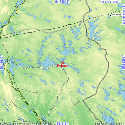
These maps also provides idea of topography and contour of this city, they are displayed at different zoom levels. More info about maps, scale and edge coordinates you can find below images.
| \ | Map #1 | Map #2 | Topo.Map |
| Scale [m] | 143..203 m | 143..214 m | × |
| Scale [ft] | 469..666 ft | 469..702 ft | × |
| Average | 158.4 m = 520 ft | 163.1 m = 535 ft | × |
| Width | 4.26 km = 2.6 mi | 8.53 km = 5.3 mi | 136.4 km = 84.8 mi |
| Height | 4.26 km = 2.6 mi | 8.53 km = 5.3 mi | 136.4 km = 84.8 mi |
| ↑Max Latitude | 64.152496° | 64.171648° | 64.74011° |
| Latitude at center | 64.13333° | 64.13333° | 64.13333° |
| ↓Min Latitude | 64.114151° | 64.094959° | 63.513° |
| ← Min Longitude | 29.472725° | 29.428779° | 28.11042° |
| Longitude center | 29.51667° | 29.51667° | 29.51667° |
| →Max Longitude | 29.560615° | 29.604561° | 30.92292° |
Nearby cities:
Cities around Kuhmo sort by population:
• Kajaani elevation 145 m
87.2 km,  276°
276°
• Lieksa 95 m
94.1 km,  164°
164°
• Sotkamo 134 m
53.4 km,  270°
270°
• Suomussalmi 193 m
88.7 km,  340°
340°
• Nurmes 91 m
68.3 km,  195°
195°
• Vuokatti 168 m
59.9 km, 271°
• Juuka 115 m
100.9 km,  187°
187°
• Paltamo 150 m
87.1 km,  291°
291°
• Hyrynsalmi 148 m
75.8 km,  321°
321°
• Valtimo 100 m
62.6 km,  214°
214°
• Rautavaara 139 m
93.7 km,  219°
219°
• Ristijärvi 160 m
74.7 km,  303°
303°
Multilingual:
 En español:
Kuhmo elevación 166 m.
 En France:
Kuhmo élévation 166 m.


Sources and notes:
- [note 1] Map square and city borders are not equal. Map elevation data is calculated only from area inside that square.
- [src 1] Elevation data from geonames database provided with same terms of usage.
- [src 2] The elevation map of Kuhmo is generated using GMTED2010 database with 7.5 arcsec (225m) resolution.
- [src 3] Base (background) map © OpenStreetMap contributors tiles are generated by Geofabrik and OpenTopoMap.
Copyright & License:
This Kuhmo Elevation Map is licensed under CC BY-SA. You may reuse any part from this page, if you give a proper credit by linking to this URL:
 More info on terms of use page.