Jimma elevation
Jimma (Oromiya), Ethiopia elevation is 1719 meters and Jimma elevation in feet is 5640 ft above sea level [src 1]. Jimma is a populated place (feature code) with elevation that is 177 meters (581 ft) smaller than average city elevation in Ethiopia.
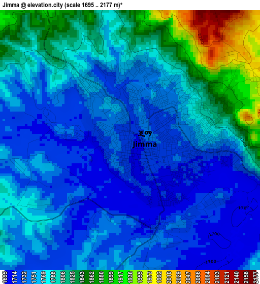
Below is the Elevation map of Jimma, which displays elevation range with different colors. Scale of the first map is from 1695 to 2177 m (5561 to 7142 ft) with average elevation of 1775.7 meters (=5826 ft) [note 1]
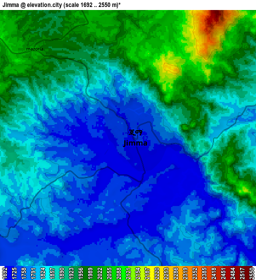
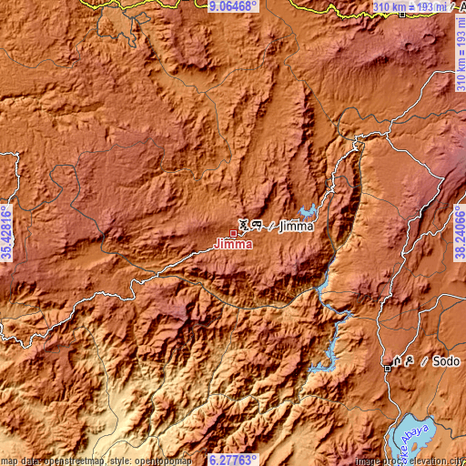
These maps also provides idea of topography and contour of this city, they are displayed at different zoom levels. More info about maps, scale and edge coordinates you can find below images.
| \ | Map #1 | Map #2 | Topo.Map |
| Scale [m] | 1695..2177 m | 1692..2550 m | × |
| Scale [ft] | 5561..7142 ft | 5551..8366 ft | × |
| Average | 1775.7 m = 5826 ft | 1861.8 m = 6108 ft | × |
| Width | 9.68 km = 6 mi | 19.37 km = 12 mi | 309.9 km = 192.6 mi |
| Height | 9.69 km = 6 mi | 19.37 km = 12 mi | 309.9 km = 192.6 mi |
| ↑Max Latitude | 7.71699° | 7.760535° | 9.06468° |
| Latitude at center | 7.67344° | 7.67344° | 7.67344° |
| ↓Min Latitude | 7.629886° | 7.586328° | 6.27763° |
| ← Min Longitude | 36.790465° | 36.746519° | 35.42816° |
| Longitude center | 36.83441° | 36.83441° | 36.83441° |
| →Max Longitude | 36.878355° | 36.922301° | 38.24066° |
Nearby cities:
Cities around Jimma sort by population:
• Sodo elevation 2045 m
136.5 km,  131°
131°
• Hosa’ina 2329 m
113.2 km,  96°
96°
• Felege Neway 1361 m
152.8 km,  177°
177°
• Āreka 1737 m
116.9 km, 125°
• Bodītī 1998 m
138.3 km,  124°
124°
• Metu 1700 m
154.4 km,  296°
296°
• Āgaro 1609 m
28.3 km,  314°
314°
• K’olīto 1781 m
143.3 km,  106°
106°
• Bedelē 2011 m
101.9 km,  328°
328°
• Bonga 1596 m
79.2 km,  236°
236°
• Mīzan Teferī 1419 m
156.5 km, 241°
• Gorē 2046 m
152.8 km,  290°
290°
Multilingual:
 En español:
Jimma elevación 1719 m.
 En France:
Jimma élévation 1719 m.


Sources and notes:
- [note 1] Map square and city borders are not equal. Map elevation data is calculated only from area inside that square.
- [src 1] Elevation data from geonames database provided with same terms of usage.
- [src 2] The elevation map of Jimma is generated using elevation data from NASA's 3 arcsec (90m) resolution SRTM data.
- [src 3] Base (background) map © OpenStreetMap contributors tiles are generated by Geofabrik and OpenTopoMap.
Copyright & License:
This Jimma Elevation Map is licensed under CC BY-SA. You may reuse any part from this page, if you give a proper credit by linking to this URL:
 More info on terms of use page.