Maych’ew elevation
Maych’ew (Tigray), Ethiopia elevation is 2400 meters and Maych’ew elevation in feet is 7874 ft above sea level [src 1]. Maych’ew is a populated place (feature code) with elevation that is 504 meters (1654 ft) bigger than average city elevation in Ethiopia.
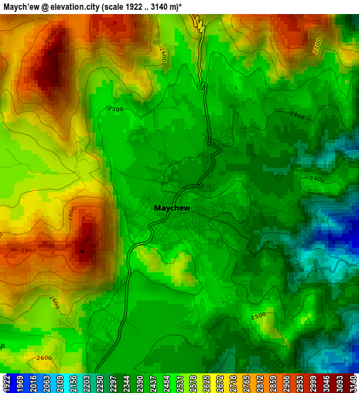
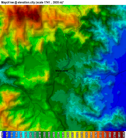
Below is the Elevation map of Maych’ew, which displays elevation range with different colors. Scale of the first map is from 1922 to 3140 m (6306 to 10302 ft) with average elevation of 2510.2 meters (=8236 ft) [note 1]
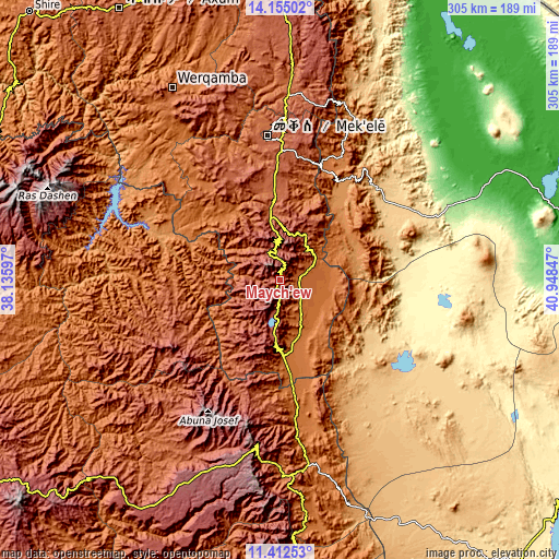
These maps also provides idea of topography and contour of this city, they are displayed at different zoom levels. More info about maps, scale and edge coordinates you can find below images.
| \ | Map #1 | Map #2 | Topo.Map |
| Scale [m] | 1922..3140 m | 1741..3935 m | × |
| Scale [ft] | 6306..10302 ft | 5712..12910 ft | × |
| Average | 2510.2 m = 8236 ft | 2555.7 m = 8385 ft | × |
| Width | 9.53 km = 5.9 mi | 19.06 km = 11.8 mi | 304.9 km = 189.5 mi |
| Height | 9.53 km = 5.9 mi | 19.06 km = 11.8 mi | 305 km = 189.5 mi |
| ↑Max Latitude | 12.830352° | 12.873196° | 14.15502° |
| Latitude at center | 12.7875° | 12.7875° | 12.7875° |
| ↓Min Latitude | 12.744641° | 12.701775° | 11.41253° |
| ← Min Longitude | 39.498275° | 39.454329° | 38.13597° |
| Longitude center | 39.54222° | 39.54222° | 39.54222° |
| →Max Longitude | 39.586165° | 39.630111° | 40.94847° |
Nearby cities:
Cities around Maych’ew sort by population:
• Mek'ele elevation 2068 m
79.2 km,  354°
354°
• Desē 2494 m
184.2 km,  176°
176°
• Kombolcha 1883 m
190.9 km,  173°
173°
• Ādīgrat 2451 m
165.8 km,  357°
357°
• Axum 2131 m
172.7 km,  329°
329°
• Korem 2487 m
31.4 km, 183°
• Debark’ 2854 m
182.8 km,  282°
282°
• Robīt 1597 m
86.3 km, 173°
• Batī 1662 m
184.8 km,  163°
163°
• Dabat 2602 m
193.9 km, 276°
• Lalībela 2481 m
99.7 km,  212°
212°
• Semera 433 m
193.6 km,  124°
124°
Multilingual:
 En español:
Maych’ew elevación 2400 m.
 En France:
Maych’ew élévation 2400 m.
 Auf Deutsch:
Maych’ew höhe über dem Meeresspiegel ist 2400 m.

Sources and notes:
- [note 1] Map square and city borders are not equal. Map elevation data is calculated only from area inside that square.
- [src 1] Elevation data from geonames database provided with same terms of usage.
- [src 2] The elevation map of Maych’ew is generated using elevation data from NASA's 3 arcsec (90m) resolution SRTM data.
- [src 3] Base (background) map © OpenStreetMap contributors tiles are generated by Geofabrik and OpenTopoMap.
Copyright & License:
This Maych’ew Elevation Map is licensed under CC BY-SA. You may reuse any part from this page, if you give a proper credit by linking to this URL:
 More info on terms of use page.