Nejo elevation
Nejo (Oromiya), Ethiopia elevation is 1888 meters and Nejo elevation in feet is 6194 ft above sea level [src 1]. Nejo is a populated place (feature code) with elevation that is 8 meters (26 ft) smaller than average city elevation in Ethiopia.
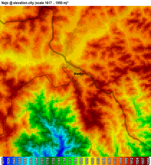
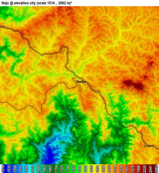
Below is the Elevation map of Nejo, which displays elevation range with different colors. Scale of the first map is from 1617 to 1950 m (5305 to 6398 ft) with average elevation of 1846.1 meters (=6057 ft) [note 1]
These maps also provides idea of topography and contour of this city, they are displayed at different zoom levels. More info about maps, scale and edge coordinates you can find below images.
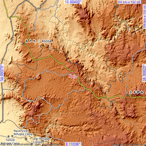
| \ | Map #1 | Map #2 | Topo.Map |
| Scale [m] | 1617..1950 m | 1514..2062 m | × |
| Scale [ft] | 5305..6398 ft | 4967..6765 ft | × |
| Average | 1846.1 m = 6057 ft | 1837.2 m = 6028 ft | × |
| Width | 9.64 km = 6 mi | 19.28 km = 12 mi | 308.4 km = 191.6 mi |
| Height | 9.64 km = 6 mi | 19.28 km = 12 mi | 308.4 km = 191.6 mi |
| ↑Max Latitude | 9.54334° | 9.586674° | 10.88402° |
| Latitude at center | 9.5° | 9.5° | 9.5° |
| ↓Min Latitude | 9.456655° | 9.413304° | 8.11036° |
| ← Min Longitude | 35.456055° | 35.412109° | 34.09375° |
| Longitude center | 35.5° | 35.5° | 35.5° |
| →Max Longitude | 35.543945° | 35.587891° | 36.90625° |
Nearby cities:
Cities around Nejo sort by population:
• Gambēla elevation 439 m
171.6 km,  215°
215°
• Gimbi 1980 m
51.9 km,  134°
134°
• Āsosa 1530 m
123.2 km,  300°
300°
• Metu 1700 m
133.7 km,  176°
176°
• Āgaro 1609 m
222.8 km,  145°
145°
• Dembī Dolo 1847 m
132.1 km, 215°
• Mendī 1665 m
55.1 km,  307°
307°
• Burē 2058 m
217.3 km,  52°
52°
• Bedelē 2011 m
149.2 km,  141°
141°
• Shambu 2576 m
175.6 km,  87°
87°
• Gorē 2046 m
150.2 km, 178°
• Gēdo 2500 m
220.6 km,  104°
104°
Multilingual:
 En español:
Nejo elevación 1888 m.
 En France:
Nejo élévation 1888 m.


Sources and notes:
- [note 1] Map square and city borders are not equal. Map elevation data is calculated only from area inside that square.
- [src 1] Elevation data from geonames database provided with same terms of usage.
- [src 2] The elevation map of Nejo is generated using elevation data from NASA's 3 arcsec (90m) resolution SRTM data.
- [src 3] Base (background) map © OpenStreetMap contributors tiles are generated by Geofabrik and OpenTopoMap.
Copyright & License:
This Nejo Elevation Map is licensed under CC BY-SA. You may reuse any part from this page, if you give a proper credit by linking to this URL:
 More info on terms of use page.