Castroviejo elevation
Castroviejo (La Rioja, Provincia de La Rioja), Spain elevation is 966 meters and Castroviejo elevation in feet is 3169 ft above sea level [src 1]. Castroviejo is a seat of a third-order administrative division (feature code) with elevation that is 363 meters (1191 ft) bigger than average city elevation in Spain.
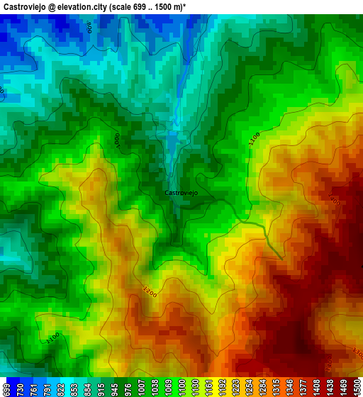
Below is the Elevation map of Castroviejo, which displays elevation range with different colors. Scale of the first map is from 699 to 1500 m (2293 to 4921 ft) with average elevation of 1093.8 meters (=3589 ft) [note 1]
These maps also provides idea of topography and contour of this city, they are displayed at different zoom levels. More info about maps, scale and edge coordinates you can find below images.
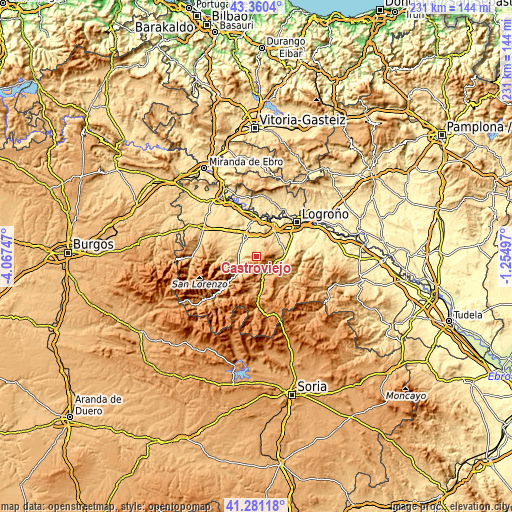
| \ | Map #1 | Topo.Map |
| Scale [m] | 699..1500 m | × |
| Scale [ft] | 2293..4921 ft | × |
| Average | 1093.8 m = 3589 ft | × |
| Width | 7.22 km = 4.5 mi | 231.2 km = 143.7 mi |
| Height | 7.22 km = 4.5 mi | 231.2 km = 143.7 mi |
| ↑Max Latitude | 42.36186° | 43.3604° |
| Latitude at center | 42.32938° | 42.32938° |
| ↓Min Latitude | 42.296883° | 41.28118° |
| ← Min Longitude | -2.705165° | -4.06747° |
| Longitude center | -2.66122° | -2.66122° |
| →Max Longitude | -2.617275° | -1.25497° |
Nearby cities:
Cities around Castroviejo sort by population:
• Baños de Río Tobía elevation 579 m
8.2 km,  274°
274°
• Arenzana de Abajo 537 m
7.9 km,  322°
322°
• Bobadilla 586 m
8.2 km,  261°
261°
• Manjarrés 632 m
7 km,  350°
350°
• Santa Coloma 765 m
4.2 km,  5°
5°
• Pedroso 771 m
5.8 km,  235°
235°
• Arenzana de Arriba 597 m
7 km,  336°
336°
• Ledesma de la Cogolla 749 m
4.9 km, 258°
• Daroca de Rioja 725 m
8 km,  54°
54°
• Nestares 866 m
7.4 km,  152°
152°
• Camproviín 669 m
5.8 km,  298°
298°
• Bezares 696 m
4.6 km, 350°
Multilingual:
 En español:
Castroviejo elevación 966 m.
 En France:
Castroviejo élévation 966 m.
 Auf Deutsch:
Castroviejo höhe über dem Meeresspiegel ist 966 m.

Sources and notes:
- [note 1] Map square and city borders are not equal. Map elevation data is calculated only from area inside that square.
- [src 1] Elevation data from geonames database provided with same terms of usage.
- [src 2] The elevation map of Castroviejo is generated using elevation data from NASA's 3 arcsec (90m) resolution SRTM data.
- [src 3] Base (background) map © OpenStreetMap contributors tiles are generated by Geofabrik and OpenTopoMap.
Copyright & License:
This Castroviejo Elevation Map is licensed under CC BY-SA. You may reuse any part from this page, if you give a proper credit by linking to this URL:
 More info on terms of use page.