Primer Ensanche elevation
Primer Ensanche (Navarre, Provincia de Navarra), Spain elevation is 458 meters and Primer Ensanche elevation in feet is 1503 ft above sea level [src 1]. Primer Ensanche is a populated place (feature code) with elevation that is 145 meters (476 ft) smaller than average city elevation in Spain.
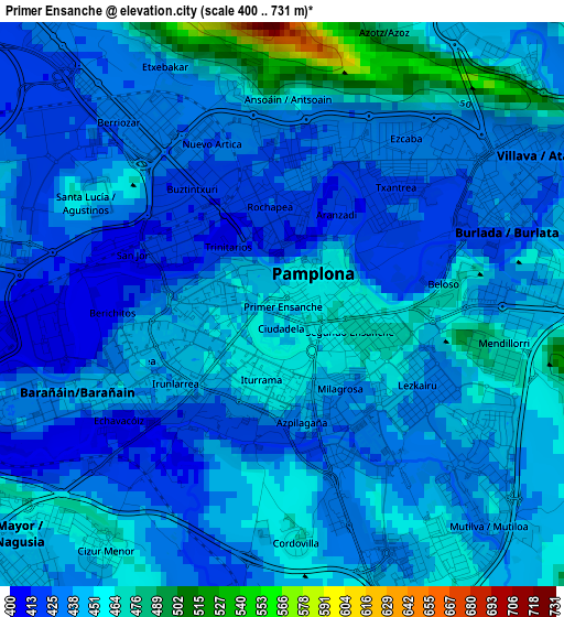
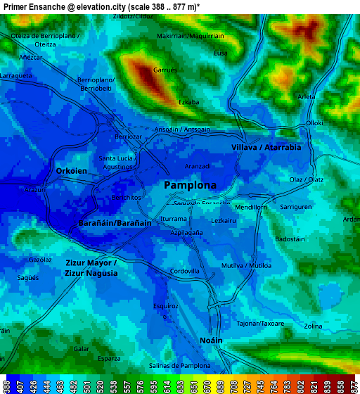
Below is the Elevation map of Primer Ensanche, which displays elevation range with different colors. Scale of the first map is from 400 to 731 m (1312 to 2398 ft) with average elevation of 442.1 meters (=1450 ft) [note 1]
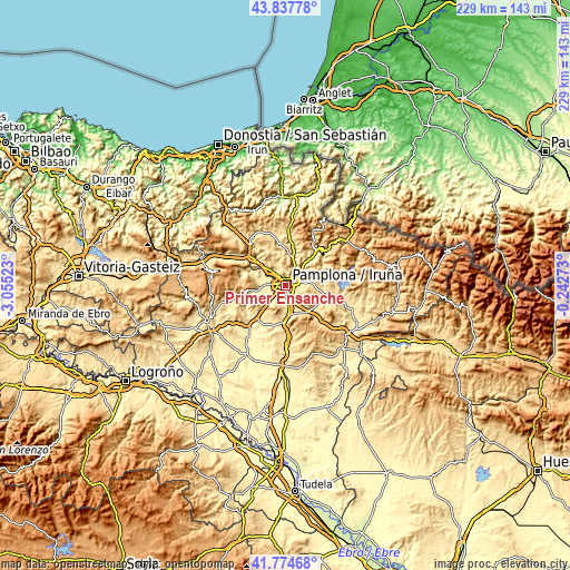
These maps also provides idea of topography and contour of this city, they are displayed at different zoom levels. More info about maps, scale and edge coordinates you can find below images.
| \ | Map #1 | Map #2 | Topo.Map |
| Scale [m] | 400..731 m | 388..877 m | × |
| Scale [ft] | 1312..2398 ft | 1273..2877 ft | × |
| Average | 442.1 m = 1450 ft | 484.7 m = 1590 ft | × |
| Width | 7.17 km = 4.5 mi | 14.34 km = 8.9 mi | 229.4 km = 142.5 mi |
| Height | 7.17 km = 4.5 mi | 14.34 km = 8.9 mi | 229.4 km = 142.5 mi |
| ↑Max Latitude | 42.847058° | 42.879269° | 43.83778° |
| Latitude at center | 42.81483° | 42.81483° | 42.81483° |
| ↓Min Latitude | 42.782585° | 42.750324° | 41.77468° |
| ← Min Longitude | -1.692925° | -1.736871° | -3.05523° |
| Longitude center | -1.64898° | -1.64898° | -1.64898° |
| →Max Longitude | -1.605035° | -1.561089° | -0.24273° |
Nearby cities:
Cities around Primer Ensanche sort by population:
• Pamplona elevation 455 m
0.5 km,  64°
64°
• Iturrama 449 m
1 km,  226°
226°
• Segundo Ensanche 460 m
0.5 km,  101°
101°
• Barañáin 441 m
2.5 km,  246°
246°
• Burlata 439 m
2.9 km,  65°
65°
• Ermitagaña 445 m
1.3 km, 250°
• Sarriguren 460 m
4.2 km,  92°
92°
• Cizur Mayor 451 m
4.5 km, 228°
• Atarrabia 436 m
3.9 km, 60°
• Berriozar 431 m
2.3 km,  320°
320°
• Huarte-Uharte 441 m
5 km, 69°
• Orkoien 445 m
4.7 km,  282°
282°
Multilingual:
 En español:
Primer Ensanche elevación 458 m.
 En France:
Primer Ensanche élévation 458 m.
 Auf Deutsch:
Primer Ensanche höhe über dem Meeresspiegel ist 458 m.

Sources and notes:
- [note 1] Map square and city borders are not equal. Map elevation data is calculated only from area inside that square.
- [src 1] Elevation data from geonames database provided with same terms of usage.
- [src 2] The elevation map of Primer Ensanche is generated using elevation data from NASA's 3 arcsec (90m) resolution SRTM data.
- [src 3] Base (background) map © OpenStreetMap contributors tiles are generated by Geofabrik and OpenTopoMap.
Copyright & License:
This Primer Ensanche Elevation Map is licensed under CC BY-SA. You may reuse any part from this page, if you give a proper credit by linking to this URL:
 More info on terms of use page.