La Bordeta elevation
La Bordeta (Catalonia, Província de Barcelona), Spain elevation is 34 meters and La Bordeta elevation in feet is 112 ft above sea level [src 1]. La Bordeta is a section of populated place (feature code) with elevation that is 569 meters (1867 ft) smaller than average city elevation in Spain.
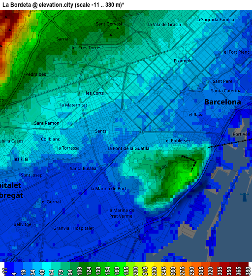
Below is the Elevation map of La Bordeta, which displays elevation range with different colors. Scale of the first map is from -11 to 380 m (-36 to 1247 ft) with average elevation of 54.5 meters (=179 ft) [note 1]
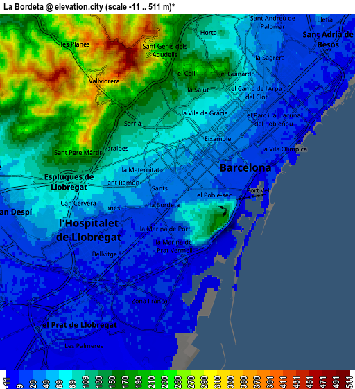
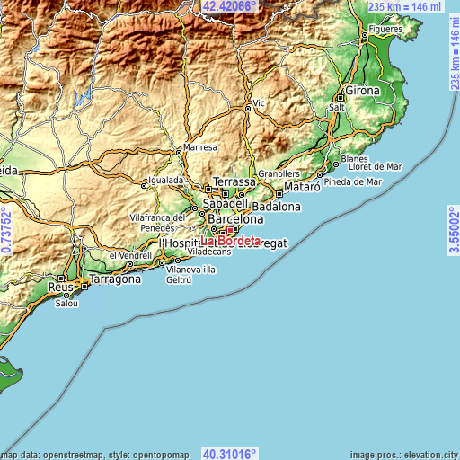
These maps also provides idea of topography and contour of this city, they are displayed at different zoom levels. More info about maps, scale and edge coordinates you can find below images.
| \ | Map #1 | Map #2 | Topo.Map |
| Scale [m] | -11..380 m | -11..511 m | × |
| Scale [ft] | -36..1247 ft | -36..1677 ft | × |
| Average | 54.5 m = 179 ft | 92 m = 302 ft | × |
| Width | 7.33 km = 4.6 mi | 14.67 km = 9.1 mi | 234.7 km = 145.8 mi |
| Height | 7.33 km = 4.6 mi | 14.67 km = 9.1 mi | 234.7 km = 145.8 mi |
| ↑Max Latitude | 41.406939° | 41.439891° | 42.42066° |
| Latitude at center | 41.37397° | 41.37397° | 41.37397° |
| ↓Min Latitude | 41.340985° | 41.307982° | 40.31016° |
| ← Min Longitude | 2.099825° | 2.055879° | 0.73752° |
| Longitude center | 2.14377° | 2.14377° | 2.14377° |
| →Max Longitude | 2.187715° | 2.231661° | 3.55002° |
Nearby cities:
Cities around La Bordeta sort by population:
• Sants-Montjuïc elevation 44 m
0.9 km,  99°
99°
• Les Corts 73 m
1.9 km,  321°
321°
• la Nova Esquerra de l'Eixample 45 m
1.1 km,  23°
23°
• Barri de les Corts 68 m
1.6 km,  332°
332°
• l'Antiga Esquerra de l'Eixample 48 m
2 km,  29°
29°
• Sants 45 m
0.5 km,  274°
274°
• Poble Sec 31 m
1.6 km,  87°
87°
• Sant Antoni 35 m
1.4 km,  68°
68°
• la Marina de Port 20 m
1.6 km,  191°
191°
• Sants - Badal 41 m
1.3 km, 273°
• Hostafrancs 38 m
0.3 km,  349°
349°
• la Font de la Guatlla 48 m
0.5 km,  168°
168°
Multilingual:
 En español:
La Bordeta elevación 34 m.
 En France:
La Bordeta élévation 34 m.
 Auf Deutsch:
La Bordeta höhe über dem Meeresspiegel ist 34 m.

Sources and notes:
- [note 1] Map square and city borders are not equal. Map elevation data is calculated only from area inside that square.
- [src 1] Elevation data from geonames database provided with same terms of usage.
- [src 2] The elevation map of La Bordeta is generated using elevation data from NASA's 3 arcsec (90m) resolution SRTM data.
- [src 3] Base (background) map © OpenStreetMap contributors tiles are generated by Geofabrik and OpenTopoMap.
Copyright & License:
This La Bordeta Elevation Map is licensed under CC BY-SA. You may reuse any part from this page, if you give a proper credit by linking to this URL:
 More info on terms of use page.