S'Agaró elevation
S'Agaró (Catalonia, Província de Girona), Spain elevation is 17 meters and S'Agaró elevation in feet is 56 ft above sea level [src 1]. S'Agaró is a populated place (feature code) with elevation that is 586 meters (1923 ft) smaller than average city elevation in Spain.
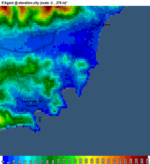
Below is the Elevation map of S'Agaró, which displays elevation range with different colors. Scale of the first map is from -2 to 276 m (-7 to 906 ft) with average elevation of 50.4 meters (=165 ft) [note 1]
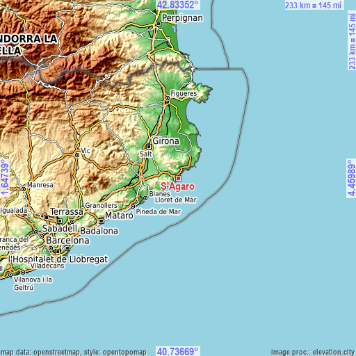
These maps also provides idea of topography and contour of this city, they are displayed at different zoom levels. More info about maps, scale and edge coordinates you can find below images.
| \ | Map #1 | Topo.Map |
| Scale [m] | -2..276 m | × |
| Scale [ft] | -7..906 ft | × |
| Average | 50.4 m = 165 ft | × |
| Width | 7.29 km = 4.5 mi | 233.1 km = 144.8 mi |
| Height | 7.29 km = 4.5 mi | 233.1 km = 144.8 mi |
| ↑Max Latitude | 41.826435° | 42.83352° |
| Latitude at center | 41.79368° | 41.79368° |
| ↓Min Latitude | 41.760908° | 40.73669° |
| ← Min Longitude | 3.009695° | 1.64739° |
| Longitude center | 3.05364° | 3.05364° |
| →Max Longitude | 3.097585° | 4.45989° |
Nearby cities:
Cities around S'Agaró sort by population:
• Palafrugell elevation 69 m
16.5 km,  33°
33°
• Sant Feliu de Guíxols 12 m
2 km,  235°
235°
• Palamós 11 m
8.7 km,  45°
45°
• Calonge 15 m
7.5 km,  16°
16°
• la Bisbal d'Empordà 66 m
17.4 km,  359°
359°
• Castell-Platja d'Aro 8 m
2.9 km, 23°
• Cassà de la Selva 157 m
18.1 km,  305°
305°
• Llagostera 136 m
13.8 km,  285°
285°
• Santa Cristina d'Aro 55 m
5.1 km,  299°
299°
• Tossa de Mar 25 m
13.1 km,  229°
229°
• Cruïlles 40 m
17.6 km,  350°
350°
• Torrent 45 m
18.7 km, 18°
Multilingual:
 En español:
Sagaro, Sagaró, S'agaro elevación 17 m.
 En France:
S'Agaró élévation 17 m.


Sources and notes:
- [note 1] Map square and city borders are not equal. Map elevation data is calculated only from area inside that square.
- [src 1] Elevation data from geonames database provided with same terms of usage.
- [src 2] The elevation map of S'Agaró is generated using elevation data from NASA's 3 arcsec (90m) resolution SRTM data.
- [src 3] Base (background) map © OpenStreetMap contributors tiles are generated by Geofabrik and OpenTopoMap.
Copyright & License:
This S'Agaró Elevation Map is licensed under CC BY-SA. You may reuse any part from this page, if you give a proper credit by linking to this URL:
 More info on terms of use page.