Sant Cristòfol de les Fonts elevation
Sant Cristòfol de les Fonts (Catalonia, Província de Girona), Spain elevation is 472 meters and Sant Cristòfol de les Fonts elevation in feet is 1549 ft above sea level [src 1]. Sant Cristòfol de les Fonts is a populated place (feature code) with elevation that is 131 meters (430 ft) smaller than average city elevation in Spain.
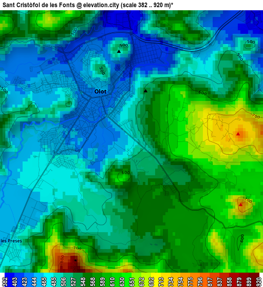
Below is the Elevation map of Sant Cristòfol de les Fonts, which displays elevation range with different colors. Scale of the first map is from 382 to 920 m (1253 to 3018 ft) with average elevation of 532.3 meters (=1746 ft) [note 1]
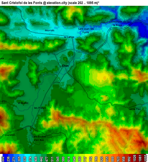
These maps also provides idea of topography and contour of this city, they are displayed at different zoom levels. More info about maps, scale and edge coordinates you can find below images.
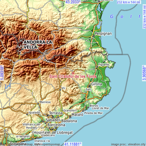
| \ | Map #1 | Map #2 | Topo.Map |
| Scale [m] | 382..920 m | 202..1095 m | × |
| Scale [ft] | 1253..3018 ft | 663..3593 ft | × |
| Average | 532.3 m = 1746 ft | 541.6 m = 1777 ft | × |
| Width | 7.24 km = 4.5 mi | 14.49 km = 9 mi | 231.8 km = 144 mi |
| Height | 7.24 km = 4.5 mi | 14.49 km = 9 mi | 231.8 km = 144 mi |
| ↑Max Latitude | 42.202202° | 42.234748° | 43.2033° |
| Latitude at center | 42.16964° | 42.16964° | 42.16964° |
| ↓Min Latitude | 42.137061° | 42.104465° | 41.11881° |
| ← Min Longitude | 2.455485° | 2.411539° | 1.09318° |
| Longitude center | 2.49943° | 2.49943° | 2.49943° |
| →Max Longitude | 2.543375° | 2.587321° | 3.90568° |
Nearby cities:
Cities around Sant Cristòfol de les Fonts sort by population:
• Olot elevation 438 m
1.5 km,  328°
328°
• Sant Joan les Fonts 343 m
4.8 km,  13°
13°
• les Planes d'Hostoles 356 m
13 km,  164°
164°
• Santa Pau 489 m
6.6 km,  115°
115°
• Sant Esteve d'en Bas 485 m
6.7 km,  211°
211°
• Argelaguer 189 m
12.8 km,  66°
66°
• Sales de Llierca 273 m
14.3 km,  60°
60°
• Sant Ferriol 309 m
14.2 km,  76°
76°
• Sant Miquel de Campmajor 215 m
15.7 km,  104°
104°
• Mieres 283 m
12.6 km,  114°
114°
• Sant Aniol de Finestres 411 m
11.4 km,  140°
140°
• Sant Feliu de Pallerols 467 m
10.3 km,  175°
175°
Multilingual:
 En español:
Sant Cristòfol de les Fonts elevación 472 m.
 En France:
Sant Cristòfol de les Fonts élévation 472 m.
 Auf Deutsch:
Sant Cristòfol de les Fonts höhe über dem Meeresspiegel ist 472 m.
 На русском:
Sant Cristòfol de les Fonts высота над уровнем моря 472 м
Sources and notes:
- [note 1] Map square and city borders are not equal. Map elevation data is calculated only from area inside that square.
- [src 1] Elevation data from geonames database provided with same terms of usage.
- [src 2] The elevation map of Sant Cristòfol de les Fonts is generated using elevation data from NASA's 3 arcsec (90m) resolution SRTM data.
- [src 3] Base (background) map © OpenStreetMap contributors tiles are generated by Geofabrik and OpenTopoMap.
Copyright & License:
This Sant Cristòfol de les Fonts Elevation Map is licensed under CC BY-SA. You may reuse any part from this page, if you give a proper credit by linking to this URL:
 More info on terms of use page.