Nou Barris elevation
Nou Barris (Catalonia, Província de Barcelona), Spain elevation is 85 meters and Nou Barris elevation in feet is 279 ft above sea level [src 1]. Nou Barris is a section of populated place (feature code) with elevation that is 518 meters (1699 ft) smaller than average city elevation in Spain.
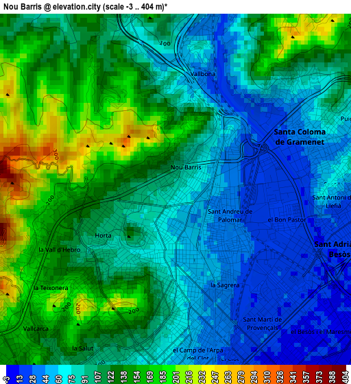
Below is the Elevation map of Nou Barris, which displays elevation range with different colors. Scale of the first map is from -3 to 404 m (-10 to 1325 ft) with average elevation of 105.5 meters (=346 ft) [note 1]
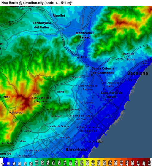
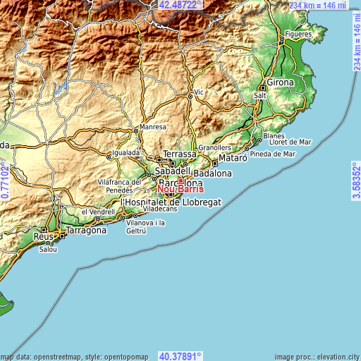
These maps also provides idea of topography and contour of this city, they are displayed at different zoom levels. More info about maps, scale and edge coordinates you can find below images.
| \ | Map #1 | Map #2 | Topo.Map |
| Scale [m] | -3..404 m | -4..511 m | × |
| Scale [ft] | -10..1325 ft | -13..1677 ft | × |
| Average | 105.5 m = 346 ft | 129.4 m = 425 ft | × |
| Width | 7.33 km = 4.6 mi | 14.65 km = 9.1 mi | 234.4 km = 145.6 mi |
| Height | 7.33 km = 4.6 mi | 14.65 km = 9.1 mi | 234.4 km = 145.6 mi |
| ↑Max Latitude | 41.474564° | 41.507482° | 42.48722° |
| Latitude at center | 41.44163° | 41.44163° | 41.44163° |
| ↓Min Latitude | 41.408679° | 41.375711° | 40.37891° |
| ← Min Longitude | 2.133325° | 2.089379° | 0.77102° |
| Longitude center | 2.17727° | 2.17727° | 2.17727° |
| →Max Longitude | 2.221215° | 2.265161° | 3.58352° |
Nearby cities:
Cities around Nou Barris sort by population:
• Sant Andreu elevation 34 m
1.3 km,  123°
123°
• Barri de Sant Andreu 38 m
1.2 km, 115°
• la Prosperitat 69 m
0.4 km,  73°
73°
• Vilapicina i la Torre Llobeta 66 m
1.5 km,  190°
190°
• Porta 54 m
0.8 km,  170°
170°
• les Roquetes 146 m
0.7 km,  346°
346°
• el Turó de la Peira 94 m
1.2 km,  213°
213°
• la Guineueta 95 m
0.8 km,  245°
245°
• Verdun 93 m
0.2 km,  311°
311°
• la Trinitat Nova 75 m
1.2 km,  32°
32°
• Canyelles 168 m
1.2 km,  288°
288°
• Can Peguera 85 m
1.2 km,  230°
230°
Multilingual:
 En español:
Distrito Nou Barris, Distrito de Nou Barris elevación 85 m.
 En France:
Nou Barris élévation 85 m.
 Auf Deutsch:
Nou Barris höhe über dem Meeresspiegel ist 85 m.

Sources and notes:
- [note 1] Map square and city borders are not equal. Map elevation data is calculated only from area inside that square.
- [src 1] Elevation data from geonames database provided with same terms of usage.
- [src 2] The elevation map of Nou Barris is generated using elevation data from NASA's 3 arcsec (90m) resolution SRTM data.
- [src 3] Base (background) map © OpenStreetMap contributors tiles are generated by Geofabrik and OpenTopoMap.
Copyright & License:
This Nou Barris Elevation Map is licensed under CC BY-SA. You may reuse any part from this page, if you give a proper credit by linking to this URL:
 More info on terms of use page.