Abanto elevation
Abanto (Aragon, Provincia de Zaragoza), Spain elevation is 930 meters and Abanto elevation in feet is 3051 ft above sea level [src 1]. Abanto is a seat of a third-order administrative division (feature code) with elevation that is 327 meters (1073 ft) bigger than average city elevation in Spain.
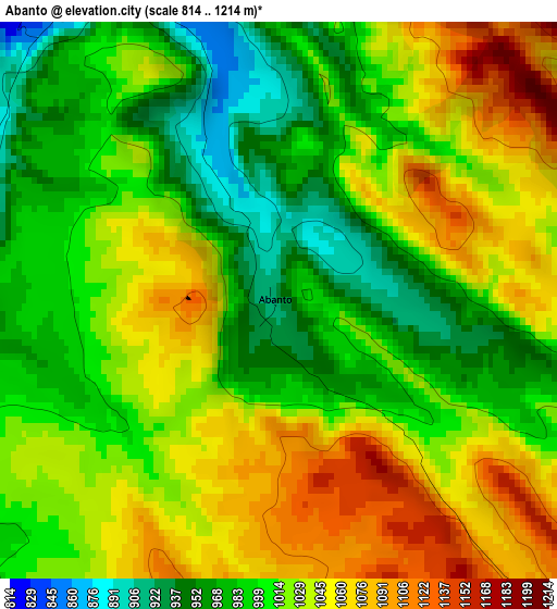
Below is the Elevation map of Abanto, which displays elevation range with different colors. Scale of the first map is from 814 to 1214 m (2671 to 3983 ft) with average elevation of 1017.9 meters (=3340 ft) [note 1]
These maps also provides idea of topography and contour of this city, they are displayed at different zoom levels. More info about maps, scale and edge coordinates you can find below images.
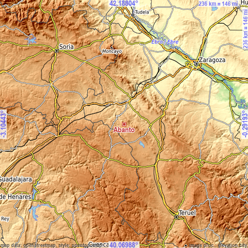
| \ | Map #1 | Topo.Map |
| Scale [m] | 814..1214 m | × |
| Scale [ft] | 2671..3983 ft | × |
| Average | 1017.9 m = 3340 ft | × |
| Width | 7.36 km = 4.6 mi | 235.5 km = 146.3 mi |
| Height | 7.36 km = 4.6 mi | 235.5 km = 146.3 mi |
| ↑Max Latitude | 41.170598° | 42.18804° |
| Latitude at center | 41.13751° | 41.13751° |
| ↓Min Latitude | 41.104405° | 40.06988° |
| ← Min Longitude | -1.742125° | -3.10443° |
| Longitude center | -1.69818° | -1.69818° |
| →Max Longitude | -1.654235° | -0.29193° |
Nearby cities:
Cities around Abanto sort by population:
• Nuévalos elevation 718 m
11.3 km,  317°
317°
• Monterde 799 m
5.1 km, 322°
• Cubel 1113 m
6.9 km,  132°
132°
• Atea 839 m
12.2 km,  77°
77°
• Campillo de Aragón 1056 m
12.3 km,  264°
264°
• Alarba 852 m
10.3 km,  43°
43°
• Cimballa 919 m
7.5 km,  237°
237°
• Olvés 795 m
12.2 km,  20°
20°
• Castejón de Alarba 930 m
7.3 km,  45°
45°
• Torralba de los Frailes 1093 m
11.7 km,  164°
164°
• Aldehuela de Liestos 997 m
8.2 km,  181°
181°
• Acered 800 m
8.7 km,  64°
64°
Multilingual:
 En español:
Abanto elevación 930 m.
 En France:
Abanto élévation 930 m.


Sources and notes:
- [note 1] Map square and city borders are not equal. Map elevation data is calculated only from area inside that square.
- [src 1] Elevation data from geonames database provided with same terms of usage.
- [src 2] The elevation map of Abanto is generated using elevation data from NASA's 3 arcsec (90m) resolution SRTM data.
- [src 3] Base (background) map © OpenStreetMap contributors tiles are generated by Geofabrik and OpenTopoMap.
Copyright & License:
This Abanto Elevation Map is licensed under CC BY-SA. You may reuse any part from this page, if you give a proper credit by linking to this URL:
 More info on terms of use page.