Adalia elevation
Adalia (Castille and León, Provincia de Valladolid), Spain elevation is 777 meters and Adalia elevation in feet is 2549 ft above sea level [src 1]. Adalia is a seat of a third-order administrative division (feature code) with elevation that is 174 meters (571 ft) bigger than average city elevation in Spain.
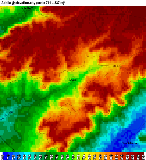
Below is the Elevation map of Adalia, which displays elevation range with different colors. Scale of the first map is from 711 to 837 m (2333 to 2746 ft) with average elevation of 793.4 meters (=2603 ft) [note 1]
These maps also provides idea of topography and contour of this city, they are displayed at different zoom levels. More info about maps, scale and edge coordinates you can find below images.
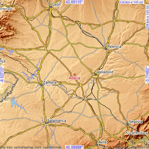
| \ | Map #1 | Topo.Map |
| Scale [m] | 711..837 m | × |
| Scale [ft] | 2333..2746 ft | × |
| Average | 793.4 m = 2603 ft | × |
| Width | 7.3 km = 4.5 mi | 233.7 km = 145.2 mi |
| Height | 7.3 km = 4.5 mi | 233.7 km = 145.2 mi |
| ↑Max Latitude | 41.681769° | 42.69115° |
| Latitude at center | 41.64894° | 41.64894° |
| ↓Min Latitude | 41.616094° | 40.58959° |
| ← Min Longitude | -5.165015° | -6.52732° |
| Longitude center | -5.12107° | -5.12107° |
| →Max Longitude | -5.077125° | -3.71482° |
Nearby cities:
Cities around Adalia sort by population:
• Torrelobatón elevation 752 m
8 km,  89°
89°
• Mota del Marqués 748 m
5 km,  248°
248°
• San Cebrián de Mazote 761 m
4.2 km,  326°
326°
• Vega de Valdetronco 716 m
6.2 km,  173°
173°
• Gallegos de Hornija 716 m
4.8 km,  155°
155°
• Villalbarba 719 m
9.1 km,  236°
236°
• Villasexmir 726 m
4.8 km,  102°
102°
• Marzales 708 m
7 km,  189°
189°
• Berceruelo 775 m
10.6 km,  136°
136°
• San Pelayo 775 m
8 km,  64°
64°
• Torrecilla de la Torre 760 m
6.3 km,  71°
71°
• San Salvador 719 m
4.2 km, 138°
Multilingual:
 En español:
Adalia elevación 777 m.
 En France:
Adalia élévation 777 m.


Sources and notes:
- [note 1] Map square and city borders are not equal. Map elevation data is calculated only from area inside that square.
- [src 1] Elevation data from geonames database provided with same terms of usage.
- [src 2] The elevation map of Adalia is generated using elevation data from NASA's 3 arcsec (90m) resolution SRTM data.
- [src 3] Base (background) map © OpenStreetMap contributors tiles are generated by Geofabrik and OpenTopoMap.
Copyright & License:
This Adalia Elevation Map is licensed under CC BY-SA. You may reuse any part from this page, if you give a proper credit by linking to this URL:
 More info on terms of use page.