Adrados elevation
Adrados (Castille and León, Provincia de Segovia), Spain elevation is 885 meters and Adrados elevation in feet is 2904 ft above sea level [src 1]. Adrados is a seat of a third-order administrative division (feature code) with elevation that is 282 meters (925 ft) bigger than average city elevation in Spain.
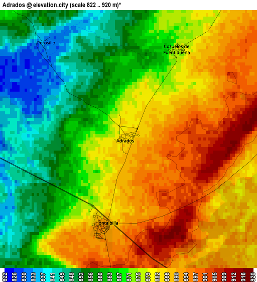
Below is the Elevation map of Adrados, which displays elevation range with different colors. Scale of the first map is from 822 to 920 m (2697 to 3018 ft) with average elevation of 874 meters (=2867 ft) [note 1]
These maps also provides idea of topography and contour of this city, they are displayed at different zoom levels. More info about maps, scale and edge coordinates you can find below images.
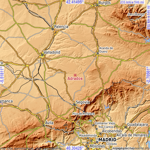
| \ | Map #1 | Topo.Map |
| Scale [m] | 822..920 m | × |
| Scale [ft] | 2697..3018 ft | × |
| Average | 874 m = 2867 ft | × |
| Width | 7.33 km = 4.6 mi | 234.7 km = 145.8 mi |
| Height | 7.33 km = 4.6 mi | 234.7 km = 145.8 mi |
| ↑Max Latitude | 41.401132° | 42.41495° |
| Latitude at center | 41.36816° | 41.36816° |
| ↓Min Latitude | 41.335172° | 40.30425° |
| ← Min Longitude | -4.155805° | -5.51811° |
| Longitude center | -4.11186° | -4.11186° |
| →Max Longitude | -4.067915° | -2.70561° |
Nearby cities:
Cities around Adrados sort by population:
• Olombrada elevation 875 m
6.6 km,  321°
321°
• Lastras de Cuéllar 905 m
7.9 km,  176°
176°
• Hontalbilla 892 m
2.6 km,  197°
197°
• Fuentesaúco de Fuentidueña 899 m
7.5 km,  33°
33°
• Torrecilla del Pinar 878 m
6.2 km,  84°
84°
• Frumales 820 m
6.4 km,  285°
285°
• Cozuelos de Fuentidueña 879 m
2.9 km, 28°
• Fuentepiñel 889 m
6.7 km,  59°
59°
• Fuente el Olmo de Fuentidueña 851 m
9.3 km, 82°
• Aldeasoña 850 m
12.5 km,  21°
21°
• Membibre de la Hoz 864 m
9.2 km,  8°
8°
• Perosillo 833 m
3.7 km, 318°
Multilingual:
 En español:
Adrados elevación 885 m.
 En France:
Adrados élévation 885 m.


Sources and notes:
- [note 1] Map square and city borders are not equal. Map elevation data is calculated only from area inside that square.
- [src 1] Elevation data from geonames database provided with same terms of usage.
- [src 2] The elevation map of Adrados is generated using elevation data from NASA's 3 arcsec (90m) resolution SRTM data.
- [src 3] Base (background) map © OpenStreetMap contributors tiles are generated by Geofabrik and OpenTopoMap.
Copyright & License:
This Adrados Elevation Map is licensed under CC BY-SA. You may reuse any part from this page, if you give a proper credit by linking to this URL:
 More info on terms of use page.