Alaminos elevation
Alaminos (Castille-La Mancha, Provincia de Guadalajara), Spain elevation is 1065 meters and Alaminos elevation in feet is 3494 ft above sea level [src 1]. Alaminos is a seat of a third-order administrative division (feature code) with elevation that is 462 meters (1516 ft) bigger than average city elevation in Spain.
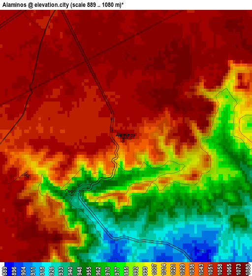
Below is the Elevation map of Alaminos, which displays elevation range with different colors. Scale of the first map is from 889 to 1080 m (2917 to 3543 ft) with average elevation of 1023.9 meters (=3359 ft) [note 1]
These maps also provides idea of topography and contour of this city, they are displayed at different zoom levels. More info about maps, scale and edge coordinates you can find below images.
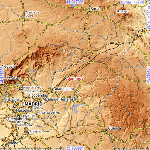
| \ | Map #1 | Topo.Map |
| Scale [m] | 889..1080 m | × |
| Scale [ft] | 2917..3543 ft | × |
| Average | 1023.9 m = 3359 ft | × |
| Width | 7.39 km = 4.6 mi | 236.5 km = 147 mi |
| Height | 7.39 km = 4.6 mi | 236.5 km = 147 mi |
| ↑Max Latitude | 40.896256° | 41.91799° |
| Latitude at center | 40.86303° | 40.86303° |
| ↓Min Latitude | 40.829787° | 39.79099° |
| ← Min Longitude | -2.769675° | -4.13198° |
| Longitude center | -2.72573° | -2.72573° |
| →Max Longitude | -2.681785° | -1.31948° |
Nearby cities:
Cities around Alaminos sort by population:
• Cifuentes elevation 898 m
12.2 km,  134°
134°
• Mandayona 877 m
10.6 km,  348°
348°
• Ledanca 911 m
9.9 km,  273°
273°
• Almadrones 1055 m
5.9 km,  316°
316°
• Algora 1112 m
12.2 km,  23°
23°
• Castejón de Henares 949 m
9.7 km,  328°
328°
• Mirabueno 1068 m
9.1 km,  0°
0°
• Argecilla 972 m
8.3 km,  284°
284°
• Masegoso de Tajuña 893 m
4.9 km,  148°
148°
• Valderrebollo 877 m
5.9 km,  182°
182°
• Cogollor 947 m
2.3 km,  223°
223°
• Barriopedro 896 m
8.4 km,  195°
195°
Multilingual:
 En español:
Alaminos elevación 1065 m.
 En France:
Alaminos élévation 1065 m.
 Auf Deutsch:
Alaminos höhe über dem Meeresspiegel ist 1065 m.

Sources and notes:
- [note 1] Map square and city borders are not equal. Map elevation data is calculated only from area inside that square.
- [src 1] Elevation data from geonames database provided with same terms of usage.
- [src 2] The elevation map of Alaminos is generated using elevation data from NASA's 3 arcsec (90m) resolution SRTM data.
- [src 3] Base (background) map © OpenStreetMap contributors tiles are generated by Geofabrik and OpenTopoMap.
Copyright & License:
This Alaminos Elevation Map is licensed under CC BY-SA. You may reuse any part from this page, if you give a proper credit by linking to this URL:
 More info on terms of use page.