Alobras elevation
Alobras (Aragon, Provincia de Teruel), Spain elevation is 1104 meters and Alobras elevation in feet is 3622 ft above sea level [src 1]. Alobras is a seat of a third-order administrative division (feature code) with elevation that is 501 meters (1644 ft) bigger than average city elevation in Spain.
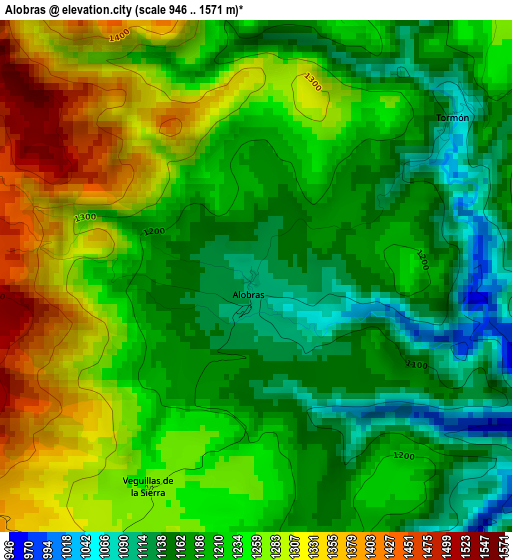
Below is the Elevation map of Alobras, which displays elevation range with different colors. Scale of the first map is from 946 to 1571 m (3104 to 5154 ft) with average elevation of 1225.2 meters (=4020 ft) [note 1]
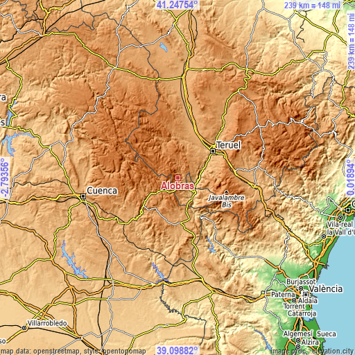
These maps also provides idea of topography and contour of this city, they are displayed at different zoom levels. More info about maps, scale and edge coordinates you can find below images.
| \ | Map #1 | Topo.Map |
| Scale [m] | 946..1571 m | × |
| Scale [ft] | 3104..5154 ft | × |
| Average | 1225.2 m = 4020 ft | × |
| Width | 7.47 km = 4.6 mi | 238.9 km = 148.4 mi |
| Height | 7.47 km = 4.6 mi | 238.9 km = 148.4 mi |
| ↑Max Latitude | 40.215256° | 41.24754° |
| Latitude at center | 40.18169° | 40.18169° |
| ↓Min Latitude | 40.148107° | 39.09882° |
| ← Min Longitude | -1.431255° | -2.79356° |
| Longitude center | -1.38731° | -1.38731° |
| →Max Longitude | -1.343365° | 0.01894° |
Nearby cities:
Cities around Alobras sort by population:
• Ademuz elevation 756 m
15.9 km,  147°
147°
• Salvacañete 1179 m
13.2 km,  226°
226°
• Castielfabib 931 m
9.1 km,  128°
128°
• Terriente 1435 m
16.2 km,  322°
322°
• Vallanca 1073 m
13.6 km,  160°
160°
• Libros 772 m
13.2 km,  98°
98°
• Tramacastiel 886 m
12.5 km,  86°
86°
• Jabaloyas 1406 m
6.7 km,  344°
344°
• Rubiales 1161 m
14.4 km,  43°
43°
• Valdecuenca 1337 m
13 km,  352°
352°
• Tormón 1067 m
3.7 km,  50°
50°
• Veguillas de la Sierra 1258 m
3.7 km,  197°
197°
Multilingual:
 En español:
Alobras elevación 1104 m.
 En France:
Alobras élévation 1104 m.
 Auf Deutsch:
Alobras höhe über dem Meeresspiegel ist 1104 m.

Sources and notes:
- [note 1] Map square and city borders are not equal. Map elevation data is calculated only from area inside that square.
- [src 1] Elevation data from geonames database provided with same terms of usage.
- [src 2] The elevation map of Alobras is generated using elevation data from NASA's 3 arcsec (90m) resolution SRTM data.
- [src 3] Base (background) map © OpenStreetMap contributors tiles are generated by Geofabrik and OpenTopoMap.
Copyright & License:
This Alobras Elevation Map is licensed under CC BY-SA. You may reuse any part from this page, if you give a proper credit by linking to this URL:
 More info on terms of use page.