Alocén elevation
Alocén (Castille-La Mancha, Provincia de Guadalajara), Spain elevation is 944 meters and Alocén elevation in feet is 3097 ft above sea level [src 1]. Alocén is a seat of a third-order administrative division (feature code) with elevation that is 341 meters (1119 ft) bigger than average city elevation in Spain.
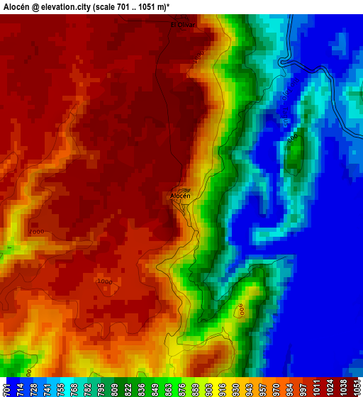
Below is the Elevation map of Alocén, which displays elevation range with different colors. Scale of the first map is from 701 to 1051 m (2300 to 3448 ft) with average elevation of 896.1 meters (=2940 ft) [note 1]
These maps also provides idea of topography and contour of this city, they are displayed at different zoom levels. More info about maps, scale and edge coordinates you can find below images.
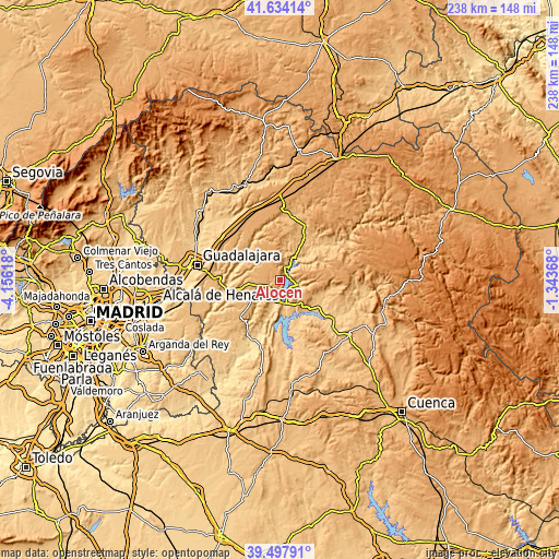
| \ | Map #1 | Topo.Map |
| Scale [m] | 701..1051 m | × |
| Scale [ft] | 2300..3448 ft | × |
| Average | 896.1 m = 2940 ft | × |
| Width | 7.42 km = 4.6 mi | 237.5 km = 147.6 mi |
| Height | 7.42 km = 4.6 mi | 237.5 km = 147.6 mi |
| ↑Max Latitude | 40.607921° | 41.63414° |
| Latitude at center | 40.57455° | 40.57455° |
| ↓Min Latitude | 40.541163° | 39.49791° |
| ← Min Longitude | -2.793875° | -4.15618° |
| Longitude center | -2.74993° | -2.74993° |
| →Max Longitude | -2.705985° | -1.34368° |
Nearby cities:
Cities around Alocén sort by population:
• Sacedón elevation 747 m
10.5 km,  172°
172°
• Pareja 768 m
8.8 km,  103°
103°
• Budia 913 m
5.9 km,  353°
353°
• Auñón 781 m
7.3 km,  209°
209°
• Alhóndiga 832 m
8.2 km,  229°
229°
• Durón 750 m
6 km,  19°
19°
• Berninches 929 m
4.3 km,  264°
264°
• Chillarón del Rey 807 m
5.6 km,  62°
62°
• Yélamos de Arriba 949 m
10.7 km,  312°
312°
• Mantiel 926 m
8.8 km, 56°
• San Andrés del Rey 1022 m
9.2 km,  320°
320°
• Alique 926 m
9 km,  81°
81°
Multilingual:
 En español:
Alocén elevación 944 m.
 En France:
Alocén élévation 944 m.


Sources and notes:
- [note 1] Map square and city borders are not equal. Map elevation data is calculated only from area inside that square.
- [src 1] Elevation data from geonames database provided with same terms of usage.
- [src 2] The elevation map of Alocén is generated using elevation data from NASA's 3 arcsec (90m) resolution SRTM data.
- [src 3] Base (background) map © OpenStreetMap contributors tiles are generated by Geofabrik and OpenTopoMap.
Copyright & License:
This Alocén Elevation Map is licensed under CC BY-SA. You may reuse any part from this page, if you give a proper credit by linking to this URL:
 More info on terms of use page.