Elexalde elevation
Elexalde (Basque Country, Bizkaia), Spain elevation is 183 meters and Elexalde elevation in feet is 600 ft above sea level [src 1]. Elexalde is a seat of a third-order administrative division (feature code) with elevation that is 420 meters (1378 ft) smaller than average city elevation in Spain.
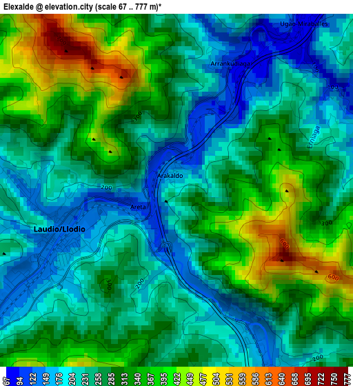
Below is the Elevation map of Elexalde, which displays elevation range with different colors. Scale of the first map is from 67 to 777 m (220 to 2549 ft) with average elevation of 277.8 meters (=911 ft) [note 1]
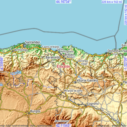
These maps also provides idea of topography and contour of this city, they are displayed at different zoom levels. More info about maps, scale and edge coordinates you can find below images.
| \ | Map #1 | Topo.Map |
| Scale [m] | 67..777 m | × |
| Scale [ft] | 220..2549 ft | × |
| Average | 277.8 m = 911 ft | × |
| Width | 7.13 km = 4.4 mi | 228.1 km = 141.7 mi |
| Height | 7.13 km = 4.4 mi | 228.1 km = 141.7 mi |
| ↑Max Latitude | 43.182053° | 44.16734° |
| Latitude at center | 43.15° | 43.15° |
| ↓Min Latitude | 43.117931° | 42.11545° |
| ← Min Longitude | -2.977275° | -4.33958° |
| Longitude center | -2.93333° | -2.93333° |
| →Max Longitude | -2.889385° | -1.52708° |
Nearby cities:
Cities around Elexalde sort by population:
• Bilbao elevation 20 m
12.5 km,  2°
2°
• Santutxu 78 m
11.6 km,  6°
6°
• Basauri 57 m
10.7 km,  21°
21°
• Galdakao 65 m
11.6 km,  39°
39°
• Laudio / Llodio 125 m
2.4 km,  252°
252°
• Arrigorriaga 50 m
7.7 km,  30°
30°
• Amurrio 219 m
12.4 km,  205°
205°
• Lezama 347 m
13.9 km,  193°
193°
• Zaratamo 153 m
9.2 km, 36°
• Areatza 141 m
14 km,  105°
105°
• Gordexola 77 m
12 km,  285°
285°
• Alonsotegi 26 m
11.4 km,  337°
337°
Multilingual:
 En español:
Aracaldo elevación 183 m.
 En France:
Elexalde élévation 183 m.
 Auf Deutsch:
Elexalde höhe über dem Meeresspiegel ist 183 m.

Sources and notes:
- [note 1] Map square and city borders are not equal. Map elevation data is calculated only from area inside that square.
- [src 1] Elevation data from geonames database provided with same terms of usage.
- [src 2] The elevation map of Elexalde is generated using elevation data from NASA's 3 arcsec (90m) resolution SRTM data.
- [src 3] Base (background) map © OpenStreetMap contributors tiles are generated by Geofabrik and OpenTopoMap.
Copyright & License:
This Elexalde Elevation Map is licensed under CC BY-SA. You may reuse any part from this page, if you give a proper credit by linking to this URL:
 More info on terms of use page.