Aranda de Duero elevation
Aranda de Duero (Castille and León, Provincia de Burgos), Spain elevation is 800 meters and Aranda de Duero elevation in feet is 2625 ft above sea level [src 1]. Aranda de Duero is a seat of a third-order administrative division (feature code) with elevation that is 197 meters (646 ft) bigger than average city elevation in Spain.
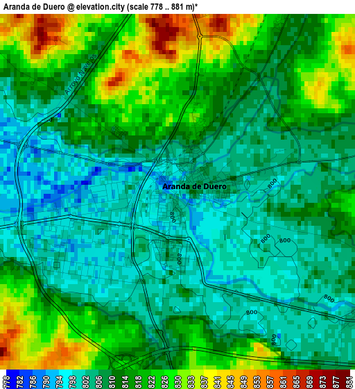
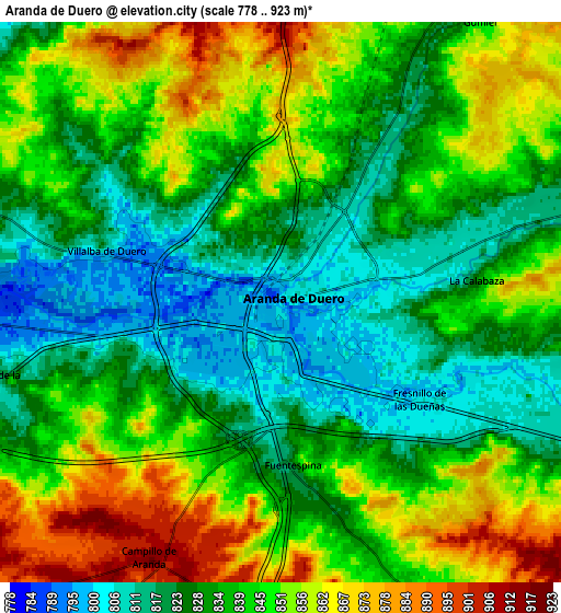
Below is the Elevation map of Aranda de Duero, which displays elevation range with different colors. Scale of the first map is from 778 to 881 m (2552 to 2890 ft) with average elevation of 812.2 meters (=2665 ft) [note 1]
These maps also provides idea of topography and contour of this city, they are displayed at different zoom levels. More info about maps, scale and edge coordinates you can find below images.
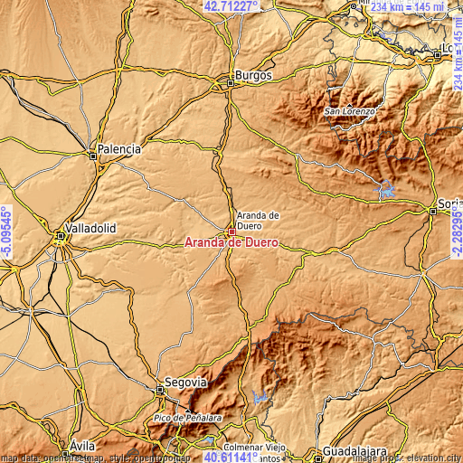
| \ | Map #1 | Map #2 | Topo.Map |
| Scale [m] | 778..881 m | 778..923 m | × |
| Scale [ft] | 2552..2890 ft | 2552..3028 ft | × |
| Average | 812.2 m = 2665 ft | 839 m = 2753 ft | × |
| Width | 7.3 km = 4.5 mi | 14.6 km = 9.1 mi | 233.6 km = 145.2 mi |
| Height | 7.3 km = 4.5 mi | 14.6 km = 9.1 mi | 233.6 km = 145.2 mi |
| ↑Max Latitude | 41.703228° | 41.736029° | 42.71227° |
| Latitude at center | 41.67041° | 41.67041° | 41.67041° |
| ↓Min Latitude | 41.637575° | 41.604724° | 40.61141° |
| ← Min Longitude | -3.733145° | -3.777091° | -5.09545° |
| Longitude center | -3.6892° | -3.6892° | -3.6892° |
| →Max Longitude | -3.645255° | -3.601309° | -2.28295° |
Nearby cities:
Cities around Aranda de Duero sort by population:
• Fuentespina elevation 825 m
4.4 km,  175°
175°
• Castrillo de la Vega 818 m
7.9 km,  254°
254°
• Villalba de Duero 809 m
4.8 km,  286°
286°
• Milagros 850 m
10.6 km, 184°
• Vadocondes 810 m
10.2 km,  109°
109°
• Fresnillo de las Dueñas 805 m
4.5 km,  125°
125°
• Villanueva de Gumiel 844 m
9.1 km,  34°
34°
• Quemada 850 m
10.1 km,  70°
70°
• Fuentelcésped 888 m
9.6 km,  155°
155°
• Campillo de Aranda 913 m
7.5 km,  206°
206°
• Quintana del Pidio 845 m
11.1 km,  332°
332°
• Torregalindo 851 m
11 km, 208°
Multilingual:
 En español:
Aranda de Duero elevación 800 m.
 En France:
Aranda de Duero élévation 800 m.
 Auf Deutsch:
Aranda de Duero höhe über dem Meeresspiegel ist 800 m.

Sources and notes:
- [note 1] Map square and city borders are not equal. Map elevation data is calculated only from area inside that square.
- [src 1] Elevation data from geonames database provided with same terms of usage.
- [src 2] The elevation map of Aranda de Duero is generated using elevation data from NASA's 3 arcsec (90m) resolution SRTM data.
- [src 3] Base (background) map © OpenStreetMap contributors tiles are generated by Geofabrik and OpenTopoMap.
Copyright & License:
This Aranda de Duero Elevation Map is licensed under CC BY-SA. You may reuse any part from this page, if you give a proper credit by linking to this URL:
 More info on terms of use page.