Arija elevation
Arija (Castille and León, Provincia de Burgos), Spain elevation is 846 meters and Arija elevation in feet is 2776 ft above sea level [src 1]. Arija is a seat of a third-order administrative division (feature code) with elevation that is 243 meters (797 ft) bigger than average city elevation in Spain.
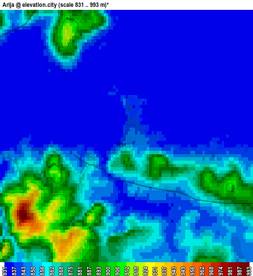
Below is the Elevation map of Arija, which displays elevation range with different colors. Scale of the first map is from 831 to 993 m (2726 to 3258 ft) with average elevation of 853.3 meters (=2800 ft) [note 1]
These maps also provides idea of topography and contour of this city, they are displayed at different zoom levels. More info about maps, scale and edge coordinates you can find below images.
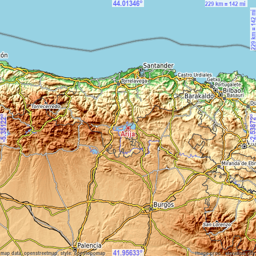
| \ | Map #1 | Topo.Map |
| Scale [m] | 831..993 m | × |
| Scale [ft] | 2726..3258 ft | × |
| Average | 853.3 m = 2800 ft | × |
| Width | 7.15 km = 4.4 mi | 228.7 km = 142.1 mi |
| Height | 7.15 km = 4.4 mi | 228.7 km = 142.1 mi |
| ↑Max Latitude | 43.025635° | 44.01346° |
| Latitude at center | 42.9935° | 42.9935° |
| ↓Min Latitude | 42.961349° | 41.95633° |
| ← Min Longitude | -3.988915° | -5.35122° |
| Longitude center | -3.94497° | -3.94497° |
| →Max Longitude | -3.901025° | -2.53872° |
Nearby cities:
Cities around Arija sort by population:
• Reinosa elevation 852 m
15.7 km,  272°
272°
• Villaescusa 875 m
18.4 km,  259°
259°
• Arenas de Iguña 177 m
22.6 km,  338°
338°
• Molledo 259 m
19.1 km, 335°
• Mataporquera 927 m
22.1 km,  233°
233°
• San Martín de Elines 724 m
19.4 km,  161°
161°
• Vega de Pas 349 m
22.4 km,  35°
35°
• Bárcena de Pie de Concha 297 m
17.3 km,  328°
328°
• San Pedro del Romeral 740 m
17 km, 37°
• Santiurde de Reinosa 681 m
13.6 km,  303°
303°
• San Miguel de Aguayo 837 m
9.4 km,  315°
315°
• Pesquera 612 m
14.7 km,  312°
312°
Multilingual:
 En español:
Arija elevación 846 m.
 En France:
Arija élévation 846 m.


Sources and notes:
- [note 1] Map square and city borders are not equal. Map elevation data is calculated only from area inside that square.
- [src 1] Elevation data from geonames database provided with same terms of usage.
- [src 2] The elevation map of Arija is generated using elevation data from NASA's 3 arcsec (90m) resolution SRTM data.
- [src 3] Base (background) map © OpenStreetMap contributors tiles are generated by Geofabrik and OpenTopoMap.
Copyright & License:
This Arija Elevation Map is licensed under CC BY-SA. You may reuse any part from this page, if you give a proper credit by linking to this URL:
 More info on terms of use page.