Arredondo elevation
Arredondo (Cantabria, Provincia de Cantabria), Spain elevation is 171 meters and Arredondo elevation in feet is 561 ft above sea level [src 1]. Arredondo is a seat of a third-order administrative division (feature code) with elevation that is 432 meters (1417 ft) smaller than average city elevation in Spain.
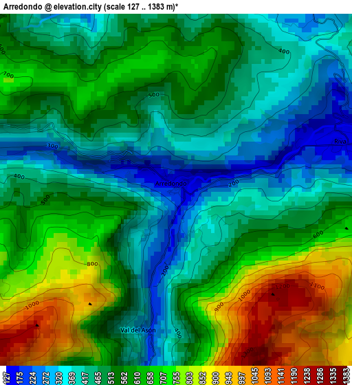
Below is the Elevation map of Arredondo, which displays elevation range with different colors. Scale of the first map is from 127 to 1383 m (417 to 4537 ft) with average elevation of 553 meters (=1814 ft) [note 1]
These maps also provides idea of topography and contour of this city, they are displayed at different zoom levels. More info about maps, scale and edge coordinates you can find below images.
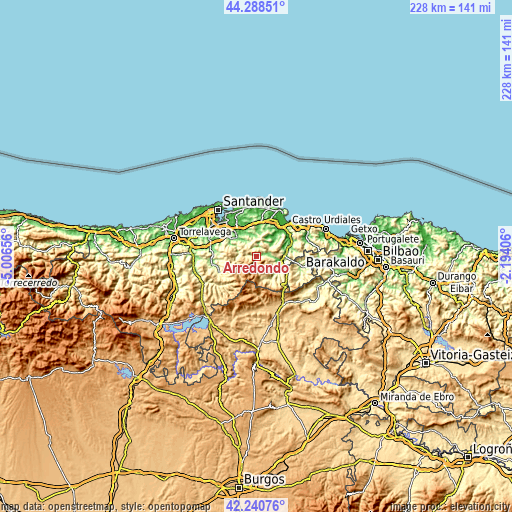
| \ | Map #1 | Topo.Map |
| Scale [m] | 127..1383 m | × |
| Scale [ft] | 417..4537 ft | × |
| Average | 553 m = 1814 ft | × |
| Width | 7.12 km = 4.4 mi | 227.7 km = 141.5 mi |
| Height | 7.12 km = 4.4 mi | 227.7 km = 141.5 mi |
| ↑Max Latitude | 43.305238° | 44.28851° |
| Latitude at center | 43.27325° | 43.27325° |
| ↓Min Latitude | 43.241245° | 42.24076° |
| ← Min Longitude | -3.644255° | -5.00656° |
| Longitude center | -3.60031° | -3.60031° |
| →Max Longitude | -3.556365° | -2.19406° |
Nearby cities:
Cities around Arredondo sort by population:
• Ampuero elevation 13 m
16.7 km,  62°
62°
• Bárcena de Cicero 20 m
18 km,  23°
23°
• Ramales de la Victoria 88 m
11.1 km,  99°
99°
• Selaya 233 m
17.9 km,  248°
248°
• Villacarriedo 204 m
17.7 km, 253°
• Limpias 36 m
17.9 km, 55°
• Hazas de Cesto 69 m
13.7 km,  3°
3°
• Solórzano 80 m
12.2 km, 4°
• Rasines 91 m
14.3 km,  75°
75°
• Liérganes 95 m
14.4 km,  304°
304°
• Lanestosa 283 m
14.3 km,  114°
114°
• Entrambasaguas 45 m
13.4 km,  330°
330°
Multilingual:
 En español:
Arredondo elevación 171 m.
 En France:
Arredondo élévation 171 m.
 Auf Deutsch:
Arredondo höhe über dem Meeresspiegel ist 171 m.

Sources and notes:
- [note 1] Map square and city borders are not equal. Map elevation data is calculated only from area inside that square.
- [src 1] Elevation data from geonames database provided with same terms of usage.
- [src 2] The elevation map of Arredondo is generated using elevation data from NASA's 3 arcsec (90m) resolution SRTM data.
- [src 3] Base (background) map © OpenStreetMap contributors tiles are generated by Geofabrik and OpenTopoMap.
Copyright & License:
This Arredondo Elevation Map is licensed under CC BY-SA. You may reuse any part from this page, if you give a proper credit by linking to this URL:
 More info on terms of use page.