Aveinte elevation
Aveinte (Castille and León, Provincia de Ávila), Spain elevation is 998 meters and Aveinte elevation in feet is 3274 ft above sea level [src 1]. Aveinte is a seat of a third-order administrative division (feature code) with elevation that is 395 meters (1296 ft) bigger than average city elevation in Spain.
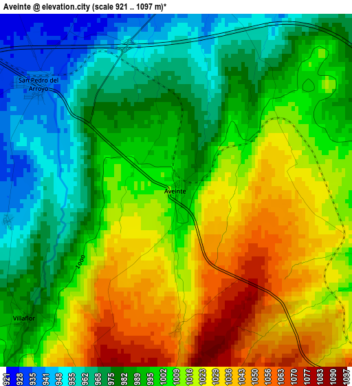
Below is the Elevation map of Aveinte, which displays elevation range with different colors. Scale of the first map is from 921 to 1097 m (3022 to 3599 ft) with average elevation of 1001 meters (=3284 ft) [note 1]
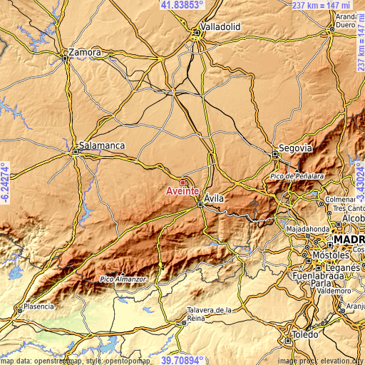
These maps also provides idea of topography and contour of this city, they are displayed at different zoom levels. More info about maps, scale and edge coordinates you can find below images.
| \ | Map #1 | Topo.Map |
| Scale [m] | 921..1097 m | × |
| Scale [ft] | 3022..3599 ft | × |
| Average | 1001 m = 3284 ft | × |
| Width | 7.4 km = 4.6 mi | 236.8 km = 147.1 mi |
| Height | 7.4 km = 4.6 mi | 236.8 km = 147.1 mi |
| ↑Max Latitude | 40.815537° | 41.83853° |
| Latitude at center | 40.78227° | 40.78227° |
| ↓Min Latitude | 40.748986° | 39.70894° |
| ← Min Longitude | -4.880435° | -6.24274° |
| Longitude center | -4.83649° | -4.83649° |
| →Max Longitude | -4.792545° | -3.43024° |
Nearby cities:
Cities around Aveinte sort by population:
• Cardeñosa elevation 1108 m
8.8 km,  120°
120°
• San Pedro del Arroyo 937 m
3.6 km,  307°
307°
• Albornos 910 m
7.2 km,  328°
328°
• Villaflor 981 m
4.1 km,  230°
230°
• Peñalba de Ávila 1062 m
7.7 km,  97°
97°
• Muñomer del Peco 897 m
9.3 km,  336°
336°
• San Juan de la Encinilla 912 m
5.3 km,  357°
357°
• Santo Tomé de Zabarcos 959 m
6.3 km,  275°
275°
• Muñogrande 944 m
8.5 km,  301°
301°
• Sigeres 966 m
8.4 km, 283°
• Brabos 983 m
8.7 km,  267°
267°
• Monsalupe 1002 m
4.9 km,  106°
106°
Multilingual:
 En español:
Aveinte elevación 998 m.
 En France:
Aveinte élévation 998 m.


Sources and notes:
- [note 1] Map square and city borders are not equal. Map elevation data is calculated only from area inside that square.
- [src 1] Elevation data from geonames database provided with same terms of usage.
- [src 2] The elevation map of Aveinte is generated using elevation data from NASA's 3 arcsec (90m) resolution SRTM data.
- [src 3] Base (background) map © OpenStreetMap contributors tiles are generated by Geofabrik and OpenTopoMap.
Copyright & License:
This Aveinte Elevation Map is licensed under CC BY-SA. You may reuse any part from this page, if you give a proper credit by linking to this URL:
 More info on terms of use page.