Ayuela elevation
Ayuela (Castille and León, Provincia de Palencia), Spain elevation is 953 meters and Ayuela elevation in feet is 3127 ft above sea level [src 1]. Ayuela is a seat of a third-order administrative division (feature code) with elevation that is 350 meters (1148 ft) bigger than average city elevation in Spain.
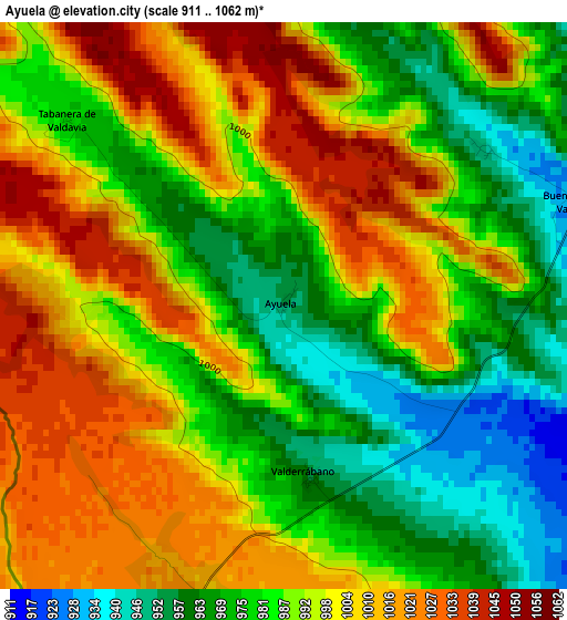
Below is the Elevation map of Ayuela, which displays elevation range with different colors. Scale of the first map is from 911 to 1062 m (2989 to 3484 ft) with average elevation of 991.4 meters (=3253 ft) [note 1]
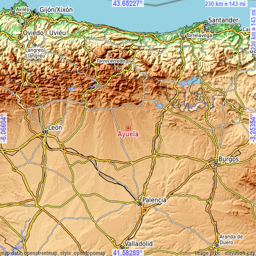
These maps also provides idea of topography and contour of this city, they are displayed at different zoom levels. More info about maps, scale and edge coordinates you can find below images.
| \ | Map #1 | Topo.Map |
| Scale [m] | 911..1062 m | × |
| Scale [ft] | 2989..3484 ft | × |
| Average | 991.4 m = 3253 ft | × |
| Width | 7.19 km = 4.5 mi | 230.1 km = 143 mi |
| Height | 7.19 km = 4.5 mi | 230.1 km = 143 mi |
| ↑Max Latitude | 42.658506° | 43.65227° |
| Latitude at center | 42.62618° | 42.62618° |
| ↓Min Latitude | 42.593837° | 41.58289° |
| ← Min Longitude | -4.703735° | -6.06604° |
| Longitude center | -4.65979° | -4.65979° |
| →Max Longitude | -4.615845° | -3.25354° |
Nearby cities:
Cities around Ayuela sort by population:
• Saldaña elevation 918 m
13.2 km,  208°
208°
• Villaluenga de la Vega 917 m
14.3 km,  217°
217°
• Buenavista de Valdavia 926 m
3.9 km,  70°
70°
• Poza de la Vega 950 m
12.5 km,  244°
244°
• Pino del Río 996 m
12.3 km,  279°
279°
• Congosto de Valdavia 976 m
10.2 km,  12°
12°
• Báscones de Ojeda 963 m
11.9 km, 65°
• Villasila de Valdavia 868 m
13.3 km,  141°
141°
• Revilla de Collazos 933 m
12.8 km,  88°
88°
• Villaeles de Valdavia 886 m
9.2 km, 137°
• Valderrábano 954 m
2.2 km,  171°
171°
• Tabanera de Valdavia 979 m
3.7 km,  309°
309°
Multilingual:
 En español:
Ayuela elevación 953 m.
 En France:
Ayuela élévation 953 m.


Sources and notes:
- [note 1] Map square and city borders are not equal. Map elevation data is calculated only from area inside that square.
- [src 1] Elevation data from geonames database provided with same terms of usage.
- [src 2] The elevation map of Ayuela is generated using elevation data from NASA's 3 arcsec (90m) resolution SRTM data.
- [src 3] Base (background) map © OpenStreetMap contributors tiles are generated by Geofabrik and OpenTopoMap.
Copyright & License:
This Ayuela Elevation Map is licensed under CC BY-SA. You may reuse any part from this page, if you give a proper credit by linking to this URL:
 More info on terms of use page.