Barbalos elevation
Barbalos (Castille and León, Provincia de Salamanca), Spain elevation is 907 meters and Barbalos elevation in feet is 2976 ft above sea level [src 1]. Barbalos is a seat of a third-order administrative division (feature code) with elevation that is 304 meters (997 ft) bigger than average city elevation in Spain.
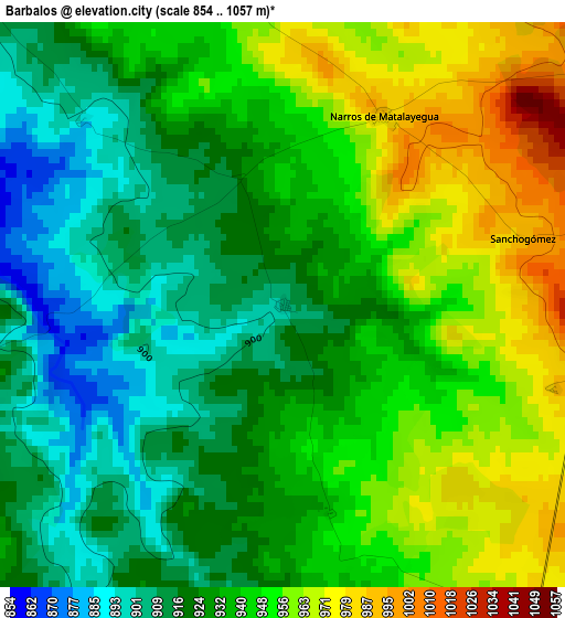
Below is the Elevation map of Barbalos, which displays elevation range with different colors. Scale of the first map is from 854 to 1057 m (2802 to 3468 ft) with average elevation of 936.1 meters (=3071 ft) [note 1]
These maps also provides idea of topography and contour of this city, they are displayed at different zoom levels. More info about maps, scale and edge coordinates you can find below images.
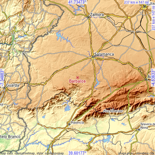
| \ | Map #1 | Topo.Map |
| Scale [m] | 854..1057 m | × |
| Scale [ft] | 2802..3468 ft | × |
| Average | 936.1 m = 3071 ft | × |
| Width | 7.41 km = 4.6 mi | 237.2 km = 147.4 mi |
| Height | 7.41 km = 4.6 mi | 237.2 km = 147.4 mi |
| ↑Max Latitude | 40.7101° | 41.73473° |
| Latitude at center | 40.67678° | 40.67678° |
| ↓Min Latitude | 40.643444° | 39.60177° |
| ← Min Longitude | -5.986525° | -7.34883° |
| Longitude center | -5.94258° | -5.94258° |
| →Max Longitude | -5.898635° | -4.53633° |
Nearby cities:
Cities around Barbalos sort by population:
• Linares de Riofrío elevation 958 m
10.5 km,  170°
170°
• Vecinos 894 m
12.6 km,  25°
25°
• Escurial de la Sierra 960 m
6.7 km,  189°
189°
• Navarredonda de la Rinconada 1026 m
9.7 km,  216°
216°
• Narros de Matalayegua 986 m
2.8 km, 28°
• Carrascal del Obispo 897 m
10.8 km,  333°
333°
• Monleón 872 m
13.5 km,  141°
141°
• Herguijuela del Campo 931 m
8.4 km,  127°
127°
• Tejeda y Segoyuela 926 m
8.5 km,  233°
233°
• Membribe de la Sierra 1027 m
11.7 km,  82°
82°
• Berrocal de Huebra 897 m
6.7 km,  313°
313°
• Sanchón de la Sagrada 876 m
10.1 km,  316°
316°
Multilingual:
 En español:
Barbalos elevación 907 m.
 En France:
Barbalos élévation 907 m.
 Auf Deutsch:
Barbalos höhe über dem Meeresspiegel ist 907 m.

Sources and notes:
- [note 1] Map square and city borders are not equal. Map elevation data is calculated only from area inside that square.
- [src 1] Elevation data from geonames database provided with same terms of usage.
- [src 2] The elevation map of Barbalos is generated using elevation data from NASA's 3 arcsec (90m) resolution SRTM data.
- [src 3] Base (background) map © OpenStreetMap contributors tiles are generated by Geofabrik and OpenTopoMap.
Copyright & License:
This Barbalos Elevation Map is licensed under CC BY-SA. You may reuse any part from this page, if you give a proper credit by linking to this URL:
 More info on terms of use page.