Begues elevation
Begues (Catalonia, Província de Barcelona), Spain elevation is 412 meters and Begues elevation in feet is 1352 ft above sea level [src 1]. Begues is a seat of a third-order administrative division (feature code) with elevation that is 191 meters (627 ft) smaller than average city elevation in Spain.
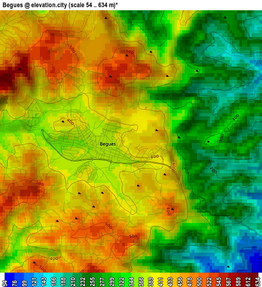
Below is the Elevation map of Begues, which displays elevation range with different colors. Scale of the first map is from 54 to 634 m (177 to 2080 ft) with average elevation of 364.3 meters (=1195 ft) [note 1]
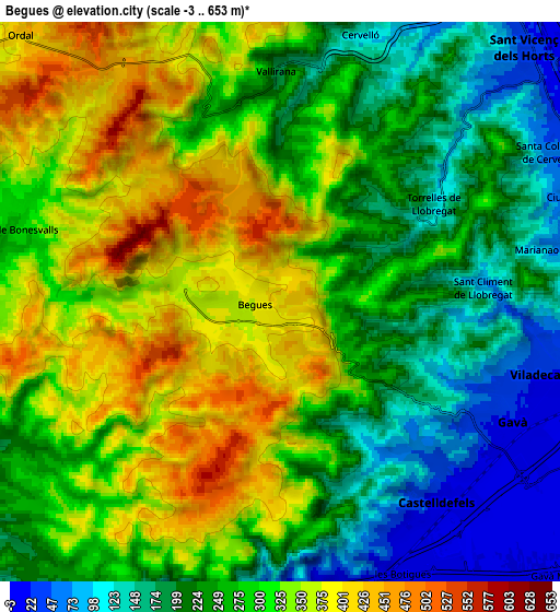
These maps also provides idea of topography and contour of this city, they are displayed at different zoom levels. More info about maps, scale and edge coordinates you can find below images.
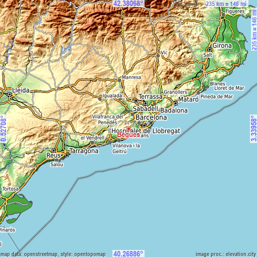
| \ | Map #1 | Map #2 | Topo.Map |
| Scale [m] | 54..634 m | -3..653 m | × |
| Scale [ft] | 177..2080 ft | -10..2142 ft | × |
| Average | 364.3 m = 1195 ft | 276.8 m = 908 ft | × |
| Width | 7.34 km = 4.6 mi | 14.68 km = 9.1 mi | 234.8 km = 145.9 mi |
| Height | 7.34 km = 4.6 mi | 14.68 km = 9.1 mi | 234.8 km = 145.9 mi |
| ↑Max Latitude | 41.366319° | 41.399292° | 42.38068° |
| Latitude at center | 41.33333° | 41.33333° | 41.33333° |
| ↓Min Latitude | 41.300324° | 41.267301° | 40.26886° |
| ← Min Longitude | 1.889385° | 1.845439° | 0.52708° |
| Longitude center | 1.93333° | 1.93333° | 1.93333° |
| →Max Longitude | 1.977275° | 2.021221° | 3.33958° |
Nearby cities:
Cities around Begues sort by population:
• Sant Boi de Llobregat elevation 45 m
8.7 km,  82°
82°
• Viladecans 20 m
7.1 km,  107°
107°
• Castelldefels 14 m
6.9 km,  153°
153°
• Gavà 22 m
6.4 km,  118°
118°
• Sant Vicenç dels Horts 61 m
9.1 km,  42°
42°
• Vallirana 191 m
5.9 km,  358°
358°
• Corbera de Llobregat 327 m
9.4 km,  353°
353°
• Cervelló 119 m
7.3 km,  17°
17°
• Santa Coloma de Cervelló 92 m
7.7 km,  60°
60°
• Torrelles de Llobregat 162 m
4.6 km,  66°
66°
• Olivella 207 m
9.9 km,  259°
259°
• Olesa de Bonesvalls 276 m
7.4 km,  288°
288°
Multilingual:
 En español:
Begas elevación 412 m.
 En France:
Begues élévation 412 m.


Sources and notes:
- [note 1] Map square and city borders are not equal. Map elevation data is calculated only from area inside that square.
- [src 1] Elevation data from geonames database provided with same terms of usage.
- [src 2] The elevation map of Begues is generated using elevation data from NASA's 3 arcsec (90m) resolution SRTM data.
- [src 3] Base (background) map © OpenStreetMap contributors tiles are generated by Geofabrik and OpenTopoMap.
Copyright & License:
This Begues Elevation Map is licensed under CC BY-SA. You may reuse any part from this page, if you give a proper credit by linking to this URL:
 More info on terms of use page.