Beleña elevation
Beleña (Castille and León, Provincia de Salamanca), Spain elevation is 884 meters and Beleña elevation in feet is 2900 ft above sea level [src 1]. Beleña is a seat of a third-order administrative division (feature code) with elevation that is 281 meters (922 ft) bigger than average city elevation in Spain.
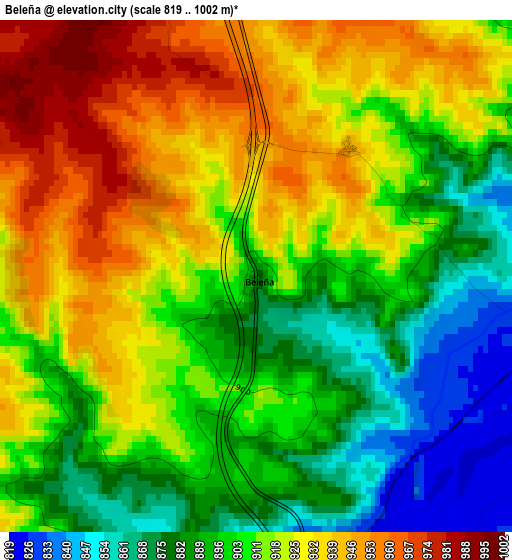
Below is the Elevation map of Beleña, which displays elevation range with different colors. Scale of the first map is from 819 to 1002 m (2687 to 3287 ft) with average elevation of 910.7 meters (=2988 ft) [note 1]
These maps also provides idea of topography and contour of this city, they are displayed at different zoom levels. More info about maps, scale and edge coordinates you can find below images.
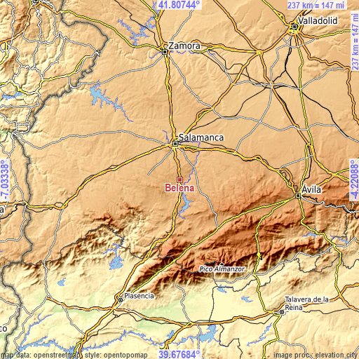
| \ | Map #1 | Topo.Map |
| Scale [m] | 819..1002 m | × |
| Scale [ft] | 2687..3287 ft | × |
| Average | 910.7 m = 2988 ft | × |
| Width | 7.4 km = 4.6 mi | 236.9 km = 147.2 mi |
| Height | 7.4 km = 4.6 mi | 236.9 km = 147.2 mi |
| ↑Max Latitude | 40.783953° | 41.80744° |
| Latitude at center | 40.75067° | 40.75067° |
| ↓Min Latitude | 40.717371° | 39.67684° |
| ← Min Longitude | -5.671075° | -7.03338° |
| Longitude center | -5.62713° | -5.62713° |
| →Max Longitude | -5.583185° | -4.22088° |
Nearby cities:
Cities around Beleña sort by population:
• Galisancho elevation 820 m
6.1 km,  96°
96°
• Pedrosillo de los Aires 961 m
7.7 km,  239°
239°
• Mozárbez 877 m
11.9 km,  350°
350°
• San Pedro de Rozados 976 m
10.2 km,  295°
295°
• Anaya de Alba 882 m
11.6 km, 102°
• Encinas de Arriba 816 m
6.4 km,  68°
68°
• Morille 931 m
8.7 km,  316°
316°
• Ejeme 816 m
7.7 km,  76°
76°
• Buenavista 944 m
2.3 km,  35°
35°
• Monterrubio de la Sierra 961 m
5.6 km,  275°
275°
• Martinamor 957 m
6.7 km,  20°
20°
• Valdemierque 941 m
8.8 km,  25°
25°
Multilingual:
 En español:
Beleña elevación 884 m.
 En France:
Beleña élévation 884 m.


Sources and notes:
- [note 1] Map square and city borders are not equal. Map elevation data is calculated only from area inside that square.
- [src 1] Elevation data from geonames database provided with same terms of usage.
- [src 2] The elevation map of Beleña is generated using elevation data from NASA's 3 arcsec (90m) resolution SRTM data.
- [src 3] Base (background) map © OpenStreetMap contributors tiles are generated by Geofabrik and OpenTopoMap.
Copyright & License:
This Beleña Elevation Map is licensed under CC BY-SA. You may reuse any part from this page, if you give a proper credit by linking to this URL:
 More info on terms of use page.