Berbegal elevation
Berbegal (Aragon, Provincia de Huesca), Spain elevation is 518 meters and Berbegal elevation in feet is 1699 ft above sea level [src 1]. Berbegal is a seat of a third-order administrative division (feature code) with elevation that is 85 meters (279 ft) smaller than average city elevation in Spain.
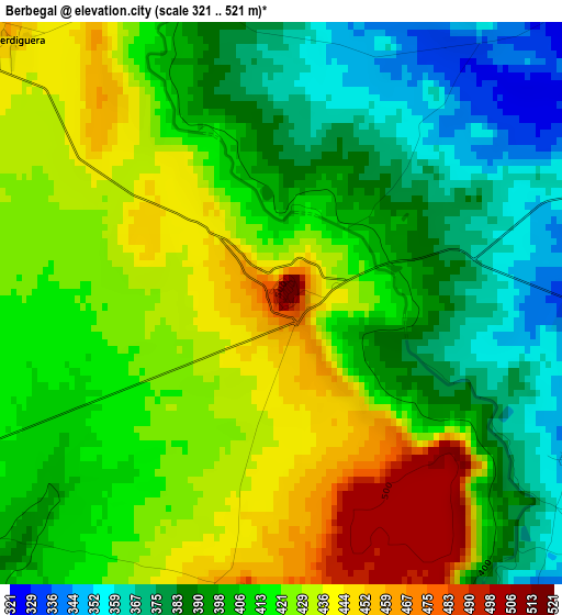
Below is the Elevation map of Berbegal, which displays elevation range with different colors. Scale of the first map is from 321 to 521 m (1053 to 1709 ft) with average elevation of 410.6 meters (=1347 ft) [note 1]
These maps also provides idea of topography and contour of this city, they are displayed at different zoom levels. More info about maps, scale and edge coordinates you can find below images.
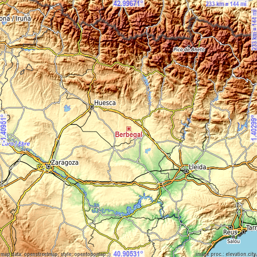
| \ | Map #1 | Topo.Map |
| Scale [m] | 321..521 m | × |
| Scale [ft] | 1053..1709 ft | × |
| Average | 410.6 m = 1347 ft | × |
| Width | 7.27 km = 4.5 mi | 232.5 km = 144.5 mi |
| Height | 7.27 km = 4.5 mi | 232.5 km = 144.5 mi |
| ↑Max Latitude | 41.99226° | 42.99671° |
| Latitude at center | 41.95959° | 41.95959° |
| ↓Min Latitude | 41.926903° | 40.90531° |
| ← Min Longitude | -0.047205° | -1.40951° |
| Longitude center | -0.00326° | -0.00326° |
| →Max Longitude | 0.040685° | 1.40299° |
Nearby cities:
Cities around Berbegal sort by population:
• Barbastro elevation 338 m
13.7 km,  51°
51°
• Castejón del Puente 358 m
13.4 km,  88°
88°
• Ilche 322 m
5 km, 93°
• Laluenga 487 m
6.4 km,  325°
325°
• Pozán de Vero 412 m
13.9 km,  11°
11°
• Castillazuelo 368 m
13.3 km,  25°
25°
• Azara 436 m
12.5 km,  350°
350°
• Peraltilla 420 m
10.6 km, 353°
• Pertusa 375 m
11.3 km,  294°
294°
• Torres de Alcanadre 391 m
8.9 km,  275°
275°
• Barbuñales 471 m
10.1 km,  316°
316°
• Laperdiguera 460 m
5 km,  313°
313°
Multilingual:
 En español:
Berbegal elevación 518 m.
 En France:
Berbegal élévation 518 m.
 Auf Deutsch:
Berbegal höhe über dem Meeresspiegel ist 518 m.

Sources and notes:
- [note 1] Map square and city borders are not equal. Map elevation data is calculated only from area inside that square.
- [src 1] Elevation data from geonames database provided with same terms of usage.
- [src 2] The elevation map of Berbegal is generated using elevation data from NASA's 3 arcsec (90m) resolution SRTM data.
- [src 3] Base (background) map © OpenStreetMap contributors tiles are generated by Geofabrik and OpenTopoMap.
Copyright & License:
This Berbegal Elevation Map is licensed under CC BY-SA. You may reuse any part from this page, if you give a proper credit by linking to this URL:
 More info on terms of use page.