Borja elevation
Borja (Aragon, Provincia de Zaragoza), Spain elevation is 458 meters and Borja elevation in feet is 1503 ft above sea level [src 1]. Borja is a seat of a third-order administrative division (feature code) with elevation that is 145 meters (476 ft) smaller than average city elevation in Spain.
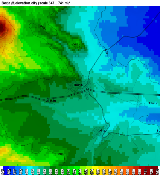
Below is the Elevation map of Borja, which displays elevation range with different colors. Scale of the first map is from 347 to 741 m (1138 to 2431 ft) with average elevation of 457.8 meters (=1502 ft) [note 1]
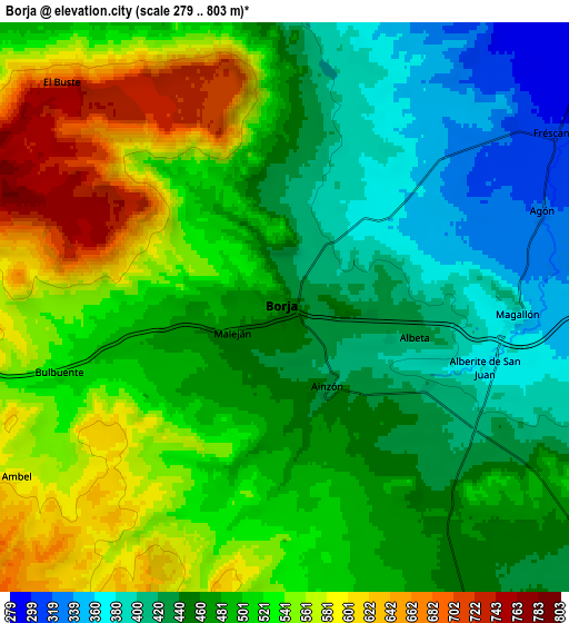
These maps also provides idea of topography and contour of this city, they are displayed at different zoom levels. More info about maps, scale and edge coordinates you can find below images.
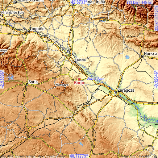
| \ | Map #1 | Map #2 | Topo.Map |
| Scale [m] | 347..741 m | 279..803 m | × |
| Scale [ft] | 1138..2431 ft | 915..2635 ft | × |
| Average | 457.8 m = 1502 ft | 491.4 m = 1612 ft | × |
| Width | 7.28 km = 4.5 mi | 14.56 km = 9 mi | 233 km = 144.8 mi |
| Height | 7.28 km = 4.5 mi | 14.56 km = 9 mi | 233 km = 144.8 mi |
| ↑Max Latitude | 41.866854° | 41.899572° | 42.8733° |
| Latitude at center | 41.83412° | 41.83412° | 41.83412° |
| ↓Min Latitude | 41.801369° | 41.768601° | 40.77779° |
| ← Min Longitude | -1.576655° | -1.620601° | -2.93896° |
| Longitude center | -1.53271° | -1.53271° | -1.53271° |
| →Max Longitude | -1.488765° | -1.444819° | -0.12646° |
Nearby cities:
Cities around Borja sort by population:
• Ainzón elevation 435 m
2.2 km,  151°
151°
• Magallón 379 m
6 km,  91°
91°
• Fuendejalón 475 m
9.6 km, 148°
• Ambel 588 m
8.1 km,  237°
237°
• Bureta 420 m
4.2 km,  119°
119°
• Maleján 470 m
1.5 km, 241°
• Fréscano 292 m
8.8 km,  51°
51°
• Bulbuente 528 m
6 km,  254°
254°
• Agón 324 m
7.1 km,  70°
70°
• Albeta 420 m
2.9 km,  107°
107°
• Bisimbre 321 m
7.8 km, 71°
• Alberite de San Juan 379 m
5.4 km, 106°
Multilingual:
 En español:
Borja elevación 458 m.
 En France:
Borja élévation 458 m.


Sources and notes:
- [note 1] Map square and city borders are not equal. Map elevation data is calculated only from area inside that square.
- [src 1] Elevation data from geonames database provided with same terms of usage.
- [src 2] The elevation map of Borja is generated using elevation data from NASA's 3 arcsec (90m) resolution SRTM data.
- [src 3] Base (background) map © OpenStreetMap contributors tiles are generated by Geofabrik and OpenTopoMap.
Copyright & License:
This Borja Elevation Map is licensed under CC BY-SA. You may reuse any part from this page, if you give a proper credit by linking to this URL:
 More info on terms of use page.