Bretocino elevation
Bretocino (Castille and León, Provincia de Zamora), Spain elevation is 716 meters and Bretocino elevation in feet is 2349 ft above sea level [src 1]. Bretocino is a seat of a third-order administrative division (feature code) with elevation that is 113 meters (371 ft) bigger than average city elevation in Spain.
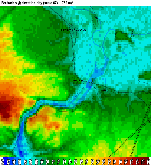
Below is the Elevation map of Bretocino, which displays elevation range with different colors. Scale of the first map is from 674 to 782 m (2211 to 2566 ft) with average elevation of 714.5 meters (=2344 ft) [note 1]
These maps also provides idea of topography and contour of this city, they are displayed at different zoom levels. More info about maps, scale and edge coordinates you can find below images.
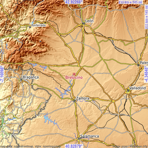
| \ | Map #1 | Topo.Map |
| Scale [m] | 674..782 m | × |
| Scale [ft] | 2211..2566 ft | × |
| Average | 714.5 m = 2344 ft | × |
| Width | 7.28 km = 4.5 mi | 232.8 km = 144.7 mi |
| Height | 7.28 km = 4.5 mi | 232.8 km = 144.7 mi |
| ↑Max Latitude | 41.917009° | 42.92266° |
| Latitude at center | 41.8843° | 41.8843° |
| ↓Min Latitude | 41.851575° | 40.82879° |
| ← Min Longitude | -5.798675° | -7.16098° |
| Longitude center | -5.75473° | -5.75473° |
| →Max Longitude | -5.710785° | -4.34848° |
Nearby cities:
Cities around Bretocino sort by population:
• Burganes de Valverde elevation 709 m
4.7 km,  330°
330°
• Villanázar 707 m
10.2 km,  347°
347°
• Santovenia 714 m
3.8 km,  99°
99°
• Granja de Moreruela 712 m
8.3 km,  170°
170°
• Santa Colomba de las Monjas 703 m
10.1 km,  35°
35°
• Barcial del Barco 716 m
9.4 km,  54°
54°
• Arcos de la Polvorosa 703 m
8.2 km, 35°
• Milles de la Polvorosa 704 m
4.7 km,  22°
22°
• Villaveza del Agua 708 m
7.4 km,  58°
58°
• Navianos de Valverde 710 m
9.3 km, 325°
• Friera de Valverde 721 m
7.8 km,  293°
293°
• Bretó 709 m
1.4 km,  113°
113°
Multilingual:
 En español:
Bretocino elevación 716 m.
 En France:
Bretocino élévation 716 m.
 Auf Deutsch:
Bretocino höhe über dem Meeresspiegel ist 716 m.

Sources and notes:
- [note 1] Map square and city borders are not equal. Map elevation data is calculated only from area inside that square.
- [src 1] Elevation data from geonames database provided with same terms of usage.
- [src 2] The elevation map of Bretocino is generated using elevation data from NASA's 3 arcsec (90m) resolution SRTM data.
- [src 3] Base (background) map © OpenStreetMap contributors tiles are generated by Geofabrik and OpenTopoMap.
Copyright & License:
This Bretocino Elevation Map is licensed under CC BY-SA. You may reuse any part from this page, if you give a proper credit by linking to this URL:
 More info on terms of use page.