Burela de Cabo elevation
Burela de Cabo (Galicia, Provincia de Lugo), Spain elevation is 132 meters and Burela de Cabo elevation in feet is 433 ft above sea level [src 1]. Burela de Cabo is a populated place (feature code) with elevation that is 471 meters (1545 ft) smaller than average city elevation in Spain.
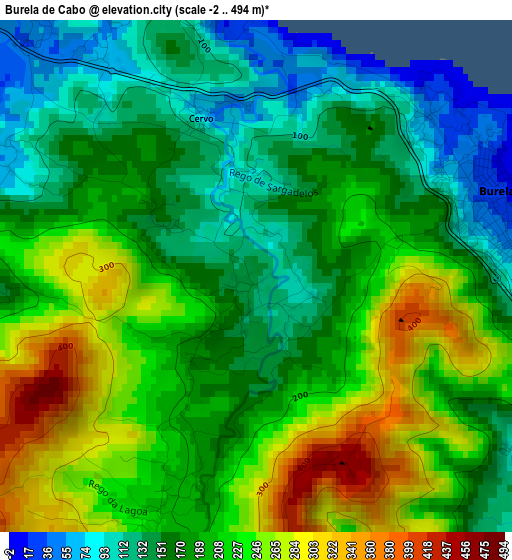
Below is the Elevation map of Burela de Cabo, which displays elevation range with different colors. Scale of the first map is from -2 to 494 m (-7 to 1621 ft) with average elevation of 193.8 meters (=636 ft) [note 1]
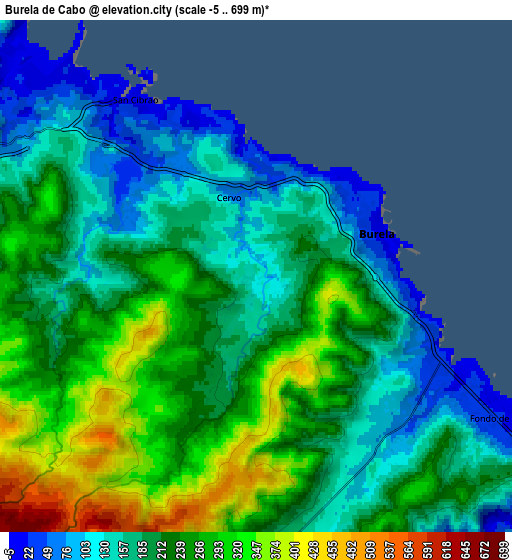
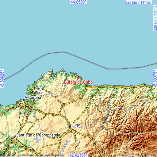
These maps also provides idea of topography and contour of this city, they are displayed at different zoom levels. More info about maps, scale and edge coordinates you can find below images.
| \ | Map #1 | Map #2 | Topo.Map |
| Scale [m] | -2..494 m | -5..699 m | × |
| Scale [ft] | -7..1621 ft | -16..2293 ft | × |
| Average | 193.8 m = 636 ft | 216.4 m = 710 ft | × |
| Width | 7.07 km = 4.4 mi | 14.14 km = 8.8 mi | 226.3 km = 140.6 mi |
| Height | 7.07 km = 4.4 mi | 14.14 km = 8.8 mi | 226.3 km = 140.6 mi |
| ↑Max Latitude | 43.681789° | 43.713561° | 44.6589° |
| Latitude at center | 43.65° | 43.65° | 43.65° |
| ↓Min Latitude | 43.618194° | 43.586371° | 42.62387° |
| ← Min Longitude | -7.443945° | -7.487891° | -8.80625° |
| Longitude center | -7.4° | -7.4° | -7.4° |
| →Max Longitude | -7.356055° | -7.312109° | -5.99375° |
Nearby cities:
Cities around Burela de Cabo sort by population:
• Viveiro elevation 26 m
15.6 km,  275°
275°
• Foz 19 m
14.8 km,  127°
127°
• Ribadeo 45 m
31.5 km,  113°
113°
• Cervo 64 m
2.4 km,  340°
340°
• Mondoñedo 544 m
27.8 km,  180°
180°
• Mondoñedo 113 m
25 km,  172°
172°
• Abadín 474 m
32.2 km,  192°
192°
• Trabada 195 m
28.2 km,  144°
144°
• Castropol 27 m
32.7 km, 114°
• Mañón 297 m
26.8 km,  270°
270°
• Barreiros 194 m
18.7 km, 134°
• Xove 56 m
9.8 km,  294°
294°
Multilingual:
 En español:
Burela de Cabo elevación 132 m.
 En France:
Burela de Cabo élévation 132 m.
 Auf Deutsch:
Burela de Cabo höhe über dem Meeresspiegel ist 132 m.

Sources and notes:
- [note 1] Map square and city borders are not equal. Map elevation data is calculated only from area inside that square.
- [src 1] Elevation data from geonames database provided with same terms of usage.
- [src 2] The elevation map of Burela de Cabo is generated using elevation data from NASA's 3 arcsec (90m) resolution SRTM data.
- [src 3] Base (background) map © OpenStreetMap contributors tiles are generated by Geofabrik and OpenTopoMap.
Copyright & License:
This Burela de Cabo Elevation Map is licensed under CC BY-SA. You may reuse any part from this page, if you give a proper credit by linking to this URL:
 More info on terms of use page.