Cabredo elevation
Cabredo (Navarre, Provincia de Navarra), Spain elevation is 656 meters and Cabredo elevation in feet is 2152 ft above sea level [src 1]. Cabredo is a seat of a third-order administrative division (feature code) with elevation that is 53 meters (174 ft) bigger than average city elevation in Spain.
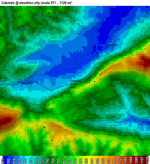
Below is the Elevation map of Cabredo, which displays elevation range with different colors. Scale of the first map is from 571 to 1128 m (1873 to 3701 ft) with average elevation of 743.8 meters (=2440 ft) [note 1]
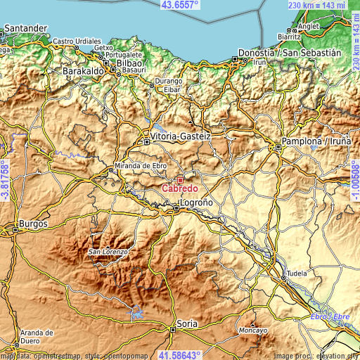
These maps also provides idea of topography and contour of this city, they are displayed at different zoom levels. More info about maps, scale and edge coordinates you can find below images.
| \ | Map #1 | Topo.Map |
| Scale [m] | 571..1128 m | × |
| Scale [ft] | 1873..3701 ft | × |
| Average | 743.8 m = 2440 ft | × |
| Width | 7.19 km = 4.5 mi | 230.1 km = 143 mi |
| Height | 7.19 km = 4.5 mi | 230.1 km = 143 mi |
| ↑Max Latitude | 42.661984° | 43.6557° |
| Latitude at center | 42.62966° | 42.62966° |
| ↓Min Latitude | 42.597319° | 41.58643° |
| ← Min Longitude | -2.455275° | -3.81758° |
| Longitude center | -2.41133° | -2.41133° |
| →Max Longitude | -2.367385° | -1.00508° |
Nearby cities:
Cities around Cabredo sort by population:
• Bargota elevation 593 m
11.3 km,  133°
133°
• Moreda Araba / Moreda de Álava 462 m
11.6 km,  178°
178°
• Aras 638 m
8.8 km,  149°
149°
• Zúñiga 568 m
11.5 km,  52°
52°
• Lapoblación 969 m
4.9 km,  235°
235°
• Espronceda 540 m
9.4 km,  112°
112°
• Aguilar de Codés 721 m
2.6 km,  137°
137°
• Genevilla 626 m
2.4 km,  44°
44°
• Marañón 625 m
2.3 km,  269°
269°
• Mirafuentes 641 m
10.8 km,  93°
93°
• Nazar 744 m
10.8 km, 85°
• Azuelo 611 m
5.6 km,  115°
115°
Multilingual:
 En español:
Cabredo elevación 656 m.
 En France:
Cabredo élévation 656 m.


Sources and notes:
- [note 1] Map square and city borders are not equal. Map elevation data is calculated only from area inside that square.
- [src 1] Elevation data from geonames database provided with same terms of usage.
- [src 2] The elevation map of Cabredo is generated using elevation data from NASA's 3 arcsec (90m) resolution SRTM data.
- [src 3] Base (background) map © OpenStreetMap contributors tiles are generated by Geofabrik and OpenTopoMap.
Copyright & License:
This Cabredo Elevation Map is licensed under CC BY-SA. You may reuse any part from this page, if you give a proper credit by linking to this URL:
 More info on terms of use page.