Calmarza elevation
Calmarza (Aragon, Provincia de Zaragoza), Spain elevation is 843 meters and Calmarza elevation in feet is 2766 ft above sea level [src 1]. Calmarza is a seat of a third-order administrative division (feature code) with elevation that is 240 meters (787 ft) bigger than average city elevation in Spain.
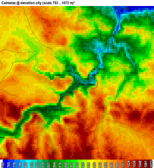
Below is the Elevation map of Calmarza, which displays elevation range with different colors. Scale of the first map is from 753 to 1073 m (2470 to 3520 ft) with average elevation of 949.8 meters (=3116 ft) [note 1]
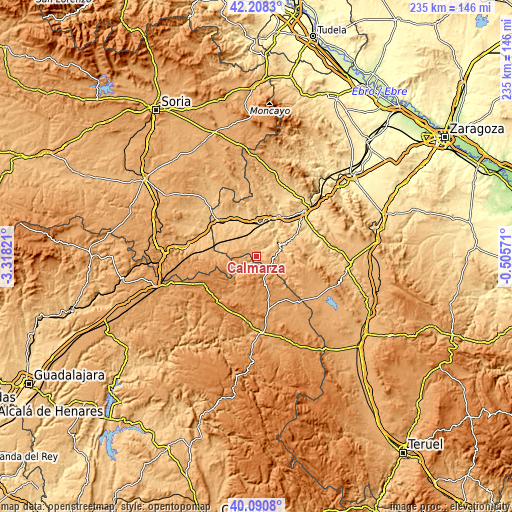
These maps also provides idea of topography and contour of this city, they are displayed at different zoom levels. More info about maps, scale and edge coordinates you can find below images.
| \ | Map #1 | Topo.Map |
| Scale [m] | 753..1073 m | × |
| Scale [ft] | 2470..3520 ft | × |
| Average | 949.8 m = 3116 ft | × |
| Width | 7.36 km = 4.6 mi | 235.4 km = 146.3 mi |
| Height | 7.36 km = 4.6 mi | 235.4 km = 146.3 mi |
| ↑Max Latitude | 41.191178° | 42.2083° |
| Latitude at center | 41.1581° | 41.1581° |
| ↓Min Latitude | 41.125005° | 40.0908° |
| ← Min Longitude | -1.955905° | -3.31821° |
| Longitude center | -1.91196° | -1.91196° |
| →Max Longitude | -1.868015° | -0.50571° |
Nearby cities:
Cities around Calmarza sort by population:
• Ibdes elevation 724 m
9.3 km,  45°
45°
• Nuévalos 718 m
11.9 km,  59°
59°
• Jaraba 762 m
4.3 km,  32°
32°
• Villel de Mesa 939 m
7.5 km,  241°
241°
• Campillo de Aragón 1056 m
6.7 km,  121°
121°
• Fuentelsaz 1123 m
11.6 km,  144°
144°
• Milmarcos 1062 m
8.5 km,  159°
159°
• Mochales 1002 m
11.1 km,  231°
231°
• Algar de Mesa 934 m
4.8 km, 237°
• Cabolafuente 946 m
12.3 km,  298°
298°
• Sisamón 1050 m
7.8 km,  280°
280°
• Godojos 766 m
12.9 km,  18°
18°
Multilingual:
 En español:
Calmarza elevación 843 m.
 En France:
Calmarza élévation 843 m.
 Auf Deutsch:
Calmarza höhe über dem Meeresspiegel ist 843 m.

Sources and notes:
- [note 1] Map square and city borders are not equal. Map elevation data is calculated only from area inside that square.
- [src 1] Elevation data from geonames database provided with same terms of usage.
- [src 2] The elevation map of Calmarza is generated using elevation data from NASA's 3 arcsec (90m) resolution SRTM data.
- [src 3] Base (background) map © OpenStreetMap contributors tiles are generated by Geofabrik and OpenTopoMap.
Copyright & License:
This Calmarza Elevation Map is licensed under CC BY-SA. You may reuse any part from this page, if you give a proper credit by linking to this URL:
 More info on terms of use page.