Campo Real elevation
Campo Real (Madrid, Provincia de Madrid), Spain elevation is 780 meters and Campo Real elevation in feet is 2559 ft above sea level [src 1]. Campo Real is a seat of a third-order administrative division (feature code) with elevation that is 177 meters (581 ft) bigger than average city elevation in Spain.
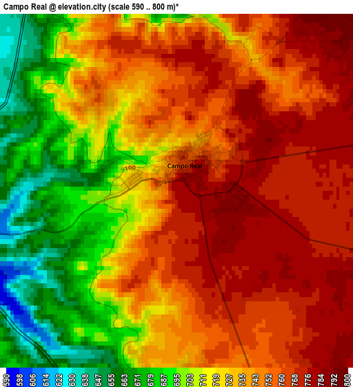
Below is the Elevation map of Campo Real, which displays elevation range with different colors. Scale of the first map is from 590 to 800 m (1936 to 2625 ft) with average elevation of 733.4 meters (=2406 ft) [note 1]
These maps also provides idea of topography and contour of this city, they are displayed at different zoom levels. More info about maps, scale and edge coordinates you can find below images.
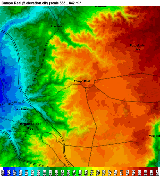
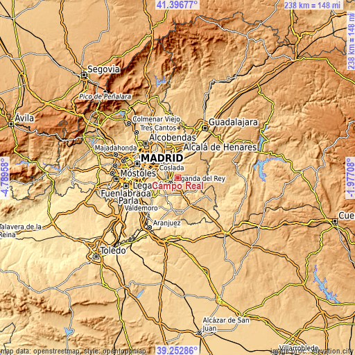
| \ | Map #1 | Map #2 | Topo.Map |
| Scale [m] | 590..800 m | 533..842 m | × |
| Scale [ft] | 1936..2625 ft | 1749..2762 ft | × |
| Average | 733.4 m = 2406 ft | 713.9 m = 2342 ft | × |
| Width | 7.45 km = 4.6 mi | 14.9 km = 9.3 mi | 238.4 km = 148.1 mi |
| Height | 7.45 km = 4.6 mi | 14.9 km = 9.3 mi | 238.4 km = 148.1 mi |
| ↑Max Latitude | 40.366821° | 40.400295° | 41.39677° |
| Latitude at center | 40.33333° | 40.33333° | 40.33333° |
| ↓Min Latitude | 40.299823° | 40.266298° | 39.25286° |
| ← Min Longitude | -3.427275° | -3.471221° | -4.78958° |
| Longitude center | -3.38333° | -3.38333° | -3.38333° |
| →Max Longitude | -3.339385° | -3.295439° | -1.97708° |
Nearby cities:
Cities around Campo Real sort by population:
• Rivas-Vaciamadrid elevation 570 m
10.8 km,  265°
265°
• Arganda 626 m
5.8 km,  231°
231°
• Mejorada del Campo 580 m
10.7 km,  308°
308°
• Velilla de San Antonio 554 m
9.3 km,  292°
292°
• Torres de la Alameda 672 m
8 km,  15°
15°
• Nuevo Baztán 831 m
12.6 km,  72°
72°
• Loeches 646 m
6.2 km,  334°
334°
• Perales de Tajuña 582 m
11.7 km,  166°
166°
• Tielmes 599 m
11.3 km,  148°
148°
• Valdilecha 705 m
8.1 km,  121°
121°
• Valverde de Alcalá 754 m
11.8 km,  38°
38°
• Pozuelo del Rey 808 m
6.6 km,  58°
58°
Multilingual:
 En español:
Campo Real elevación 780 m.
 En France:
Campo Real élévation 780 m.
 Auf Deutsch:
Campo Real höhe über dem Meeresspiegel ist 780 m.

Sources and notes:
- [note 1] Map square and city borders are not equal. Map elevation data is calculated only from area inside that square.
- [src 1] Elevation data from geonames database provided with same terms of usage.
- [src 2] The elevation map of Campo Real is generated using elevation data from NASA's 3 arcsec (90m) resolution SRTM data.
- [src 3] Base (background) map © OpenStreetMap contributors tiles are generated by Geofabrik and OpenTopoMap.
Copyright & License:
This Campo Real Elevation Map is licensed under CC BY-SA. You may reuse any part from this page, if you give a proper credit by linking to this URL:
 More info on terms of use page.