Cantalejo elevation
Cantalejo (Castille and León, Provincia de Segovia), Spain elevation is 969 meters and Cantalejo elevation in feet is 3179 ft above sea level [src 1]. Cantalejo is a seat of a third-order administrative division (feature code) with elevation that is 366 meters (1201 ft) bigger than average city elevation in Spain.
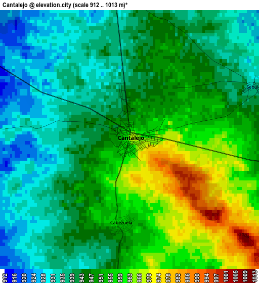
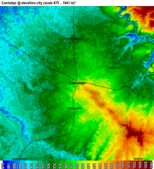
Below is the Elevation map of Cantalejo, which displays elevation range with different colors. Scale of the first map is from 912 to 1013 m (2992 to 3323 ft) with average elevation of 946.8 meters (=3106 ft) [note 1]
These maps also provides idea of topography and contour of this city, they are displayed at different zoom levels. More info about maps, scale and edge coordinates you can find below images.
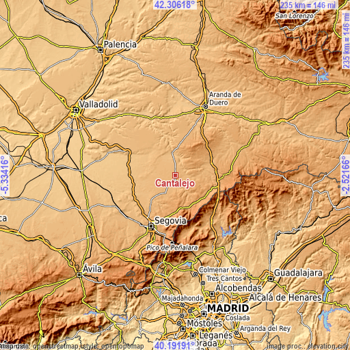
| \ | Map #1 | Map #2 | Topo.Map |
| Scale [m] | 912..1013 m | 875..1041 m | × |
| Scale [ft] | 2992..3323 ft | 2871..3415 ft | × |
| Average | 946.8 m = 3106 ft | 936.3 m = 3072 ft | × |
| Width | 7.35 km = 4.6 mi | 14.69 km = 9.1 mi | 235.1 km = 146.1 mi |
| Height | 7.35 km = 4.6 mi | 14.69 km = 9.1 mi | 235.1 km = 146.1 mi |
| ↑Max Latitude | 41.290628° | 41.323639° | 42.30618° |
| Latitude at center | 41.2576° | 41.2576° | 41.2576° |
| ↓Min Latitude | 41.224556° | 41.191495° | 40.19191° |
| ← Min Longitude | -3.971855° | -4.015801° | -5.33416° |
| Longitude center | -3.92791° | -3.92791° | -3.92791° |
| →Max Longitude | -3.883965° | -3.840019° | -2.52166° |
Nearby cities:
Cities around Cantalejo sort by population:
• Turégano elevation 940 m
13.1 km,  210°
210°
• Cabezuela 954 m
2.4 km,  187°
187°
• San Pedro de Gaíllos 990 m
10.5 km,  109°
109°
• Sebúlcor 941 m
4 km,  68°
68°
• Veganzones 917 m
9 km,  217°
217°
• Muñoveros 960 m
9.7 km, 191°
• Navalilla 902 m
9.3 km,  357°
357°
• Rebollo 986 m
9.3 km,  140°
140°
• Puebla de Pedraza 947 m
5.9 km,  168°
168°
• Arevalillo de Cega 1043 m
11.1 km,  163°
163°
• Aldealcorvo 958 m
11.5 km,  97°
97°
• Carrascal del Río 855 m
12.5 km,  11°
11°
Multilingual:
 En español:
Cantalejo elevación 969 m.
 En France:
Cantalejo élévation 969 m.
 Auf Deutsch:
Cantalejo höhe über dem Meeresspiegel ist 969 m.

Sources and notes:
- [note 1] Map square and city borders are not equal. Map elevation data is calculated only from area inside that square.
- [src 1] Elevation data from geonames database provided with same terms of usage.
- [src 2] The elevation map of Cantalejo is generated using elevation data from NASA's 3 arcsec (90m) resolution SRTM data.
- [src 3] Base (background) map © OpenStreetMap contributors tiles are generated by Geofabrik and OpenTopoMap.
Copyright & License:
This Cantalejo Elevation Map is licensed under CC BY-SA. You may reuse any part from this page, if you give a proper credit by linking to this URL:
 More info on terms of use page.