Cantallops elevation
Cantallops (Catalonia, Província de Girona), Spain elevation is 204 meters and Cantallops elevation in feet is 669 ft above sea level [src 1]. Cantallops is a seat of a third-order administrative division (feature code) with elevation that is 399 meters (1309 ft) smaller than average city elevation in Spain.
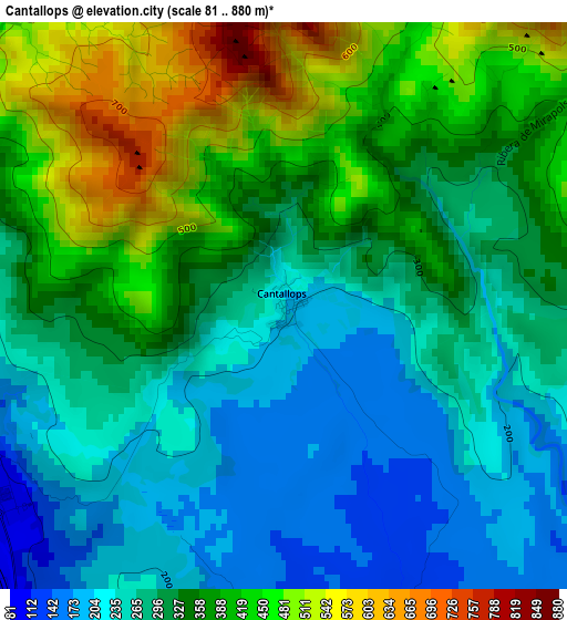
Below is the Elevation map of Cantallops, which displays elevation range with different colors. Scale of the first map is from 81 to 880 m (266 to 2887 ft) with average elevation of 327.6 meters (=1075 ft) [note 1]
These maps also provides idea of topography and contour of this city, they are displayed at different zoom levels. More info about maps, scale and edge coordinates you can find below images.
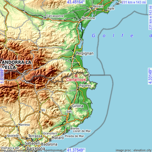
| \ | Map #1 | Topo.Map |
| Scale [m] | 81..880 m | × |
| Scale [ft] | 266..2887 ft | × |
| Average | 327.6 m = 1075 ft | × |
| Width | 7.21 km = 4.5 mi | 230.8 km = 143.4 mi |
| Height | 7.21 km = 4.5 mi | 230.8 km = 143.4 mi |
| ↑Max Latitude | 42.454592° | 43.45164° |
| Latitude at center | 42.42216° | 42.42216° |
| ↓Min Latitude | 42.389711° | 41.37549° |
| ← Min Longitude | 2.881295° | 1.51899° |
| Longitude center | 2.92524° | 2.92524° |
| →Max Longitude | 2.969185° | 4.33149° |
Nearby cities:
Cities around Cantallops sort by population:
• Agullana elevation 163 m
7.2 km,  244°
244°
• Darnius 196 m
9.7 km,  230°
230°
• Capmany 109 m
5.4 km,  184°
184°
• Pont de Molins 45 m
12 km, 178°
• Espolla 116 m
7.1 km,  119°
119°
• Rabós 110 m
9.7 km, 119°
• Mollet de Peralada 58 m
9.3 km,  138°
138°
• Vilamaniscle 156 m
12.8 km,  114°
114°
• Cabanes 26 m
13.4 km,  161°
161°
• Biure 77 m
9.7 km,  194°
194°
• Masarac 67 m
8.8 km,  153°
153°
• la Jonquera 116 m
4.3 km,  262°
262°
Multilingual:
 En español:
Cantallops elevación 204 m.
 En France:
Cantallops élévation 204 m.
 Auf Deutsch:
Cantallops höhe über dem Meeresspiegel ist 204 m.

Sources and notes:
- [note 1] Map square and city borders are not equal. Map elevation data is calculated only from area inside that square.
- [src 1] Elevation data from geonames database provided with same terms of usage.
- [src 2] The elevation map of Cantallops is generated using elevation data from NASA's 3 arcsec (90m) resolution SRTM data.
- [src 3] Base (background) map © OpenStreetMap contributors tiles are generated by Geofabrik and OpenTopoMap.
Copyright & License:
This Cantallops Elevation Map is licensed under CC BY-SA. You may reuse any part from this page, if you give a proper credit by linking to this URL:
 More info on terms of use page.