Cardedeu elevation
Cardedeu (Catalonia, Província de Barcelona), Spain elevation is 199 meters and Cardedeu elevation in feet is 653 ft above sea level [src 1]. Cardedeu is a populated place (feature code) with elevation that is 404 meters (1325 ft) smaller than average city elevation in Spain.
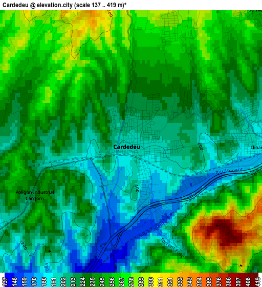
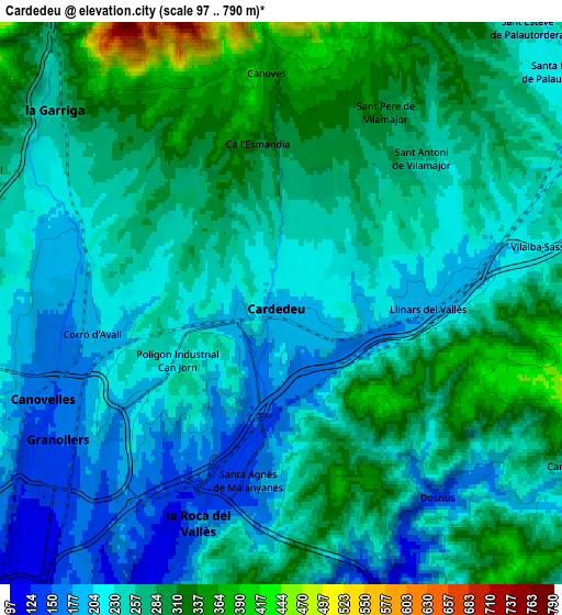
Below is the Elevation map of Cardedeu, which displays elevation range with different colors. Scale of the first map is from 137 to 419 m (449 to 1375 ft) with average elevation of 232.3 meters (=762 ft) [note 1]
These maps also provides idea of topography and contour of this city, they are displayed at different zoom levels. More info about maps, scale and edge coordinates you can find below images.
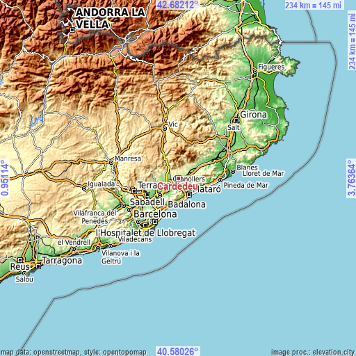
| \ | Map #1 | Map #2 | Topo.Map |
| Scale [m] | 137..419 m | 97..790 m | × |
| Scale [ft] | 449..1375 ft | 318..2592 ft | × |
| Average | 232.3 m = 762 ft | 252.5 m = 828 ft | × |
| Width | 7.3 km = 4.5 mi | 14.61 km = 9.1 mi | 233.7 km = 145.2 mi |
| Height | 7.3 km = 4.5 mi | 14.61 km = 9.1 mi | 233.7 km = 145.2 mi |
| ↑Max Latitude | 41.672594° | 41.70541° | 42.68212° |
| Latitude at center | 41.63976° | 41.63976° | 41.63976° |
| ↓Min Latitude | 41.60691° | 41.574043° | 40.58026° |
| ← Min Longitude | 2.313445° | 2.269499° | 0.95114° |
| Longitude center | 2.35739° | 2.35739° | 2.35739° |
| →Max Longitude | 2.401335° | 2.445281° | 3.76364° |
Nearby cities:
Cities around Cardedeu sort by population:
• Granollers elevation 154 m
6.8 km,  238°
238°
• Canovelles 153 m
6.7 km,  247°
247°
• la Garriga 241 m
7.8 km,  308°
308°
• La Roca del Vallès 198 m
6.6 km,  197°
197°
• Santa Maria de Palautordera 204 m
9.5 km,  50°
50°
• L'Ametlla del Vallès 266 m
8.1 km,  291°
291°
• Dosrius 323 m
8 km,  141°
141°
• Cànoves i Samalús 357 m
4.9 km,  352°
352°
• Òrrius 281 m
10 km,  183°
183°
• Les Franqueses del Vallès 194 m
5.4 km, 245°
• Sant Pere de Vilamajor 318 m
5.3 km,  23°
23°
• Llinars del Vallès 181 m
3.6 km,  101°
101°
Multilingual:
 En español:
Cardedeu elevación 199 m.
 En France:
Cardedeu élévation 199 m.
 Auf Deutsch:
Cardedeu höhe über dem Meeresspiegel ist 199 m.

Sources and notes:
- [note 1] Map square and city borders are not equal. Map elevation data is calculated only from area inside that square.
- [src 1] Elevation data from geonames database provided with same terms of usage.
- [src 2] The elevation map of Cardedeu is generated using elevation data from NASA's 3 arcsec (90m) resolution SRTM data.
- [src 3] Base (background) map © OpenStreetMap contributors tiles are generated by Geofabrik and OpenTopoMap.
Copyright & License:
This Cardedeu Elevation Map is licensed under CC BY-SA. You may reuse any part from this page, if you give a proper credit by linking to this URL:
 More info on terms of use page.