Carrascosa elevation
Carrascosa (Castille-La Mancha, Provincia de Cuenca), Spain elevation is 1259 meters and Carrascosa elevation in feet is 4131 ft above sea level [src 1]. Carrascosa is a seat of a third-order administrative division (feature code) with elevation that is 656 meters (2152 ft) bigger than average city elevation in Spain.
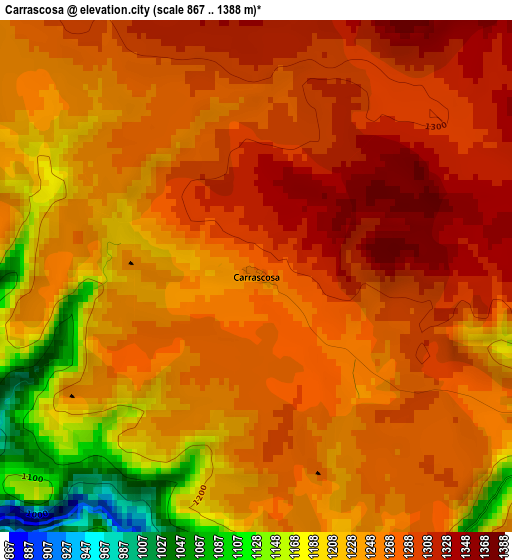
Below is the Elevation map of Carrascosa, which displays elevation range with different colors. Scale of the first map is from 867 to 1388 m (2844 to 4554 ft) with average elevation of 1256 meters (=4121 ft) [note 1]
These maps also provides idea of topography and contour of this city, they are displayed at different zoom levels. More info about maps, scale and edge coordinates you can find below images.
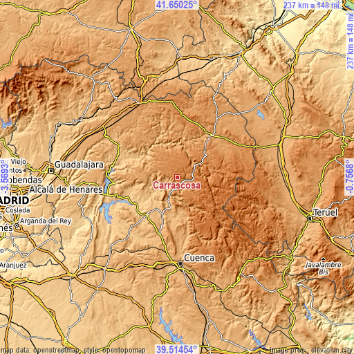
| \ | Map #1 | Topo.Map |
| Scale [m] | 867..1388 m | × |
| Scale [ft] | 2844..4554 ft | × |
| Average | 1256 m = 4121 ft | × |
| Width | 7.42 km = 4.6 mi | 237.5 km = 147.6 mi |
| Height | 7.42 km = 4.6 mi | 237.5 km = 147.6 mi |
| ↑Max Latitude | 40.624283° | 41.65025° |
| Latitude at center | 40.59092° | 40.59092° |
| ↓Min Latitude | 40.557541° | 39.51454° |
| ← Min Longitude | -2.206995° | -3.5693° |
| Longitude center | -2.16305° | -2.16305° |
| →Max Longitude | -2.119105° | -0.7568° |
Nearby cities:
Cities around Carrascosa sort by population:
• Cañizares elevation 1061 m
8.4 km,  196°
196°
• Beteta 1220 m
7.7 km,  106°
106°
• Villanueva de Alcorón 1263 m
12.4 km,  322°
322°
• Poveda de la Sierra 1191 m
12.7 km,  62°
62°
• Lagunaseca 1365 m
13.8 km,  118°
118°
• Fuertescusa 987 m
12.9 km,  184°
184°
• Peñalén 1356 m
11.4 km,  43°
43°
• Masegosa 1375 m
12.6 km, 112°
• Alcantud 847 m
15.1 km,  251°
251°
• Santa María del Val 1192 m
14.1 km,  133°
133°
• Valsalobre 1225 m
6.6 km, 63°
• Cueva del Hierro 1335 m
10.8 km,  94°
94°
Multilingual:
 En español:
Carrascosa elevación 1259 m.
 En France:
Carrascosa élévation 1259 m.
 Auf Deutsch:
Carrascosa höhe über dem Meeresspiegel ist 1259 m.

Sources and notes:
- [note 1] Map square and city borders are not equal. Map elevation data is calculated only from area inside that square.
- [src 1] Elevation data from geonames database provided with same terms of usage.
- [src 2] The elevation map of Carrascosa is generated using elevation data from NASA's 3 arcsec (90m) resolution SRTM data.
- [src 3] Base (background) map © OpenStreetMap contributors tiles are generated by Geofabrik and OpenTopoMap.
Copyright & License:
This Carrascosa Elevation Map is licensed under CC BY-SA. You may reuse any part from this page, if you give a proper credit by linking to this URL:
 More info on terms of use page.