Castilforte elevation
Castilforte (Castille-La Mancha, Provincia de Guadalajara), Spain elevation is 993 meters and Castilforte elevation in feet is 3258 ft above sea level [src 1]. Castilforte is a seat of a third-order administrative division (feature code) with elevation that is 390 meters (1280 ft) bigger than average city elevation in Spain.
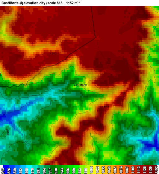
Below is the Elevation map of Castilforte, which displays elevation range with different colors. Scale of the first map is from 813 to 1152 m (2667 to 3780 ft) with average elevation of 1029.3 meters (=3377 ft) [note 1]
These maps also provides idea of topography and contour of this city, they are displayed at different zoom levels. More info about maps, scale and edge coordinates you can find below images.
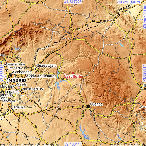
| \ | Map #1 | Topo.Map |
| Scale [m] | 813..1152 m | × |
| Scale [ft] | 2667..3780 ft | × |
| Average | 1029.3 m = 3377 ft | × |
| Width | 7.42 km = 4.6 mi | 237.6 km = 147.6 mi |
| Height | 7.42 km = 4.6 mi | 237.6 km = 147.6 mi |
| ↑Max Latitude | 40.590729° | 41.61722° |
| Latitude at center | 40.55735° | 40.55735° |
| ↓Min Latitude | 40.523954° | 39.48044° |
| ← Min Longitude | -2.476205° | -3.83851° |
| Longitude center | -2.43226° | -2.43226° |
| →Max Longitude | -2.388315° | -1.02601° |
Nearby cities:
Cities around Castilforte sort by population:
• Valdeolivas elevation 929 m
5.8 km,  190°
190°
• Salmerón 831 m
5.3 km,  255°
255°
• Millana 819 m
13 km,  244°
244°
• Albendea 838 m
7.9 km,  170°
170°
• Escamilla 1034 m
11.1 km,  265°
265°
• Peralveche 1111 m
6.1 km,  346°
346°
• Alcantud 847 m
8.5 km,  96°
96°
• San Pedro Palmiches 830 m
14.4 km, 171°
• Arbeteta 992 m
12.8 km,  11°
11°
• Villar del Infantado 769 m
12 km,  199°
199°
• Arandilla del Arroyo 893 m
6.6 km,  141°
141°
• Vindel 893 m
5.5 km,  52°
52°
Multilingual:
 En español:
Castilforte elevación 993 m.
 En France:
Castilforte élévation 993 m.
 Auf Deutsch:
Castilforte höhe über dem Meeresspiegel ist 993 m.

Sources and notes:
- [note 1] Map square and city borders are not equal. Map elevation data is calculated only from area inside that square.
- [src 1] Elevation data from geonames database provided with same terms of usage.
- [src 2] The elevation map of Castilforte is generated using elevation data from NASA's 3 arcsec (90m) resolution SRTM data.
- [src 3] Base (background) map © OpenStreetMap contributors tiles are generated by Geofabrik and OpenTopoMap.
Copyright & License:
This Castilforte Elevation Map is licensed under CC BY-SA. You may reuse any part from this page, if you give a proper credit by linking to this URL:
 More info on terms of use page.