Castrodeza elevation
Castrodeza (Castille and León, Provincia de Valladolid), Spain elevation is 760 meters and Castrodeza elevation in feet is 2493 ft above sea level [src 1]. Castrodeza is a seat of a third-order administrative division (feature code) with elevation that is 157 meters (515 ft) bigger than average city elevation in Spain.
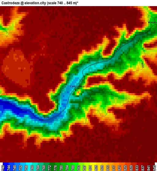
Below is the Elevation map of Castrodeza, which displays elevation range with different colors. Scale of the first map is from 740 to 845 m (2428 to 2772 ft) with average elevation of 819.5 meters (=2689 ft) [note 1]
These maps also provides idea of topography and contour of this city, they are displayed at different zoom levels. More info about maps, scale and edge coordinates you can find below images.
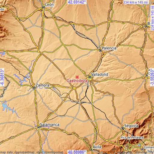
| \ | Map #1 | Topo.Map |
| Scale [m] | 740..845 m | × |
| Scale [ft] | 2428..2772 ft | × |
| Average | 819.5 m = 2689 ft | × |
| Width | 7.3 km = 4.5 mi | 233.7 km = 145.2 mi |
| Height | 7.3 km = 4.5 mi | 233.7 km = 145.2 mi |
| ↑Max Latitude | 41.682039° | 42.69142° |
| Latitude at center | 41.64921° | 41.64921° |
| ↓Min Latitude | 41.616364° | 40.58986° |
| ← Min Longitude | -5.002825° | -6.36513° |
| Longitude center | -4.95888° | -4.95888° |
| →Max Longitude | -4.914935° | -3.55263° |
Nearby cities:
Cities around Castrodeza sort by population:
• Torrelobatón elevation 752 m
5.5 km,  270°
270°
• Geria 721 m
10.4 km,  138°
138°
• Peñaflor de Hornija 842 m
7.2 km,  343°
343°
• Ciguñuela 817 m
8.5 km,  96°
96°
• Wamba 789 m
4.5 km,  49°
49°
• Villán de Tordesillas 755 m
6.9 km,  153°
153°
• Velliza 778 m
7.9 km,  172°
172°
• Villasexmir 726 m
8.9 km,  262°
262°
• Robladillo 774 m
6.1 km, 138°
• Berceruelo 775 m
9.8 km,  218°
218°
• San Pelayo 775 m
7.1 km,  299°
299°
• Torrecilla de la Torre 760 m
7.8 km,  284°
284°
Multilingual:
 En español:
Castrodeza elevación 760 m.
 En France:
Castrodeza élévation 760 m.
 Auf Deutsch:
Castrodeza höhe über dem Meeresspiegel ist 760 m.

Sources and notes:
- [note 1] Map square and city borders are not equal. Map elevation data is calculated only from area inside that square.
- [src 1] Elevation data from geonames database provided with same terms of usage.
- [src 2] The elevation map of Castrodeza is generated using elevation data from NASA's 3 arcsec (90m) resolution SRTM data.
- [src 3] Base (background) map © OpenStreetMap contributors tiles are generated by Geofabrik and OpenTopoMap.
Copyright & License:
This Castrodeza Elevation Map is licensed under CC BY-SA. You may reuse any part from this page, if you give a proper credit by linking to this URL:
 More info on terms of use page.