Cenicientos elevation
Cenicientos (Madrid, Provincia de Madrid), Spain elevation is 774 meters and Cenicientos elevation in feet is 2539 ft above sea level [src 1]. Cenicientos is a seat of a third-order administrative division (feature code) with elevation that is 171 meters (561 ft) bigger than average city elevation in Spain.
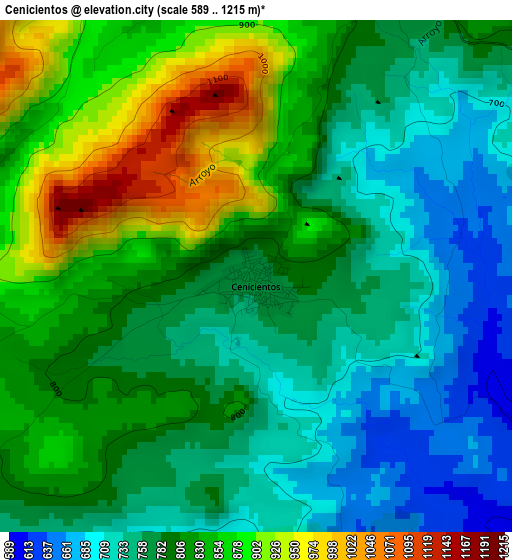
Below is the Elevation map of Cenicientos, which displays elevation range with different colors. Scale of the first map is from 589 to 1215 m (1932 to 3986 ft) with average elevation of 798.7 meters (=2620 ft) [note 1]
These maps also provides idea of topography and contour of this city, they are displayed at different zoom levels. More info about maps, scale and edge coordinates you can find below images.
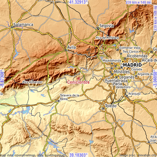
| \ | Map #1 | Topo.Map |
| Scale [m] | 589..1215 m | × |
| Scale [ft] | 1932..3986 ft | × |
| Average | 798.7 m = 2620 ft | × |
| Width | 7.46 km = 4.6 mi | 238.6 km = 148.3 mi |
| Height | 7.46 km = 4.6 mi | 238.6 km = 148.3 mi |
| ↑Max Latitude | 40.298115° | 41.32913° |
| Latitude at center | 40.26459° | 40.26459° |
| ↓Min Latitude | 40.231048° | 39.18303° |
| ← Min Longitude | -4.510775° | -5.87308° |
| Longitude center | -4.46683° | -4.46683° |
| →Max Longitude | -4.422885° | -3.06058° |
Nearby cities:
Cities around Cenicientos sort by population:
• San Martín de Valdeiglesias elevation 675 m
12.3 km,  28°
28°
• Sotillo de la Adrada 634 m
10.4 km,  286°
286°
• Escalona 464 m
12.1 km,  154°
154°
• Almorox 539 m
7.3 km,  117°
117°
• Nombela 484 m
12.5 km,  193°
193°
• Casillas 1048 m
11.2 km,  307°
307°
• Higuera de las Dueñas 632 m
12 km,  256°
256°
• Navahondilla 710 m
7.2 km,  339°
339°
• Paredes de Escalona 498 m
7.3 km,  155°
155°
• Fresnedilla 619 m
13.6 km,  254°
254°
• Rozas de Puerto Real 870 m
6 km,  346°
346°
• Cadalso de los Vidrios 807 m
4.9 km,  35°
35°
Multilingual:
 En español:
Cenicientos elevación 774 m.
 En France:
Cenicientos élévation 774 m.
 Auf Deutsch:
Cenicientos höhe über dem Meeresspiegel ist 774 m.

Sources and notes:
- [note 1] Map square and city borders are not equal. Map elevation data is calculated only from area inside that square.
- [src 1] Elevation data from geonames database provided with same terms of usage.
- [src 2] The elevation map of Cenicientos is generated using elevation data from NASA's 3 arcsec (90m) resolution SRTM data.
- [src 3] Base (background) map © OpenStreetMap contributors tiles are generated by Geofabrik and OpenTopoMap.
Copyright & License:
This Cenicientos Elevation Map is licensed under CC BY-SA. You may reuse any part from this page, if you give a proper credit by linking to this URL:
 More info on terms of use page.