Chañe elevation
Chañe (Castille and León, Provincia de Segovia), Spain elevation is 768 meters and Chañe elevation in feet is 2520 ft above sea level [src 1]. Chañe is a seat of a third-order administrative division (feature code) with elevation that is 165 meters (541 ft) bigger than average city elevation in Spain.
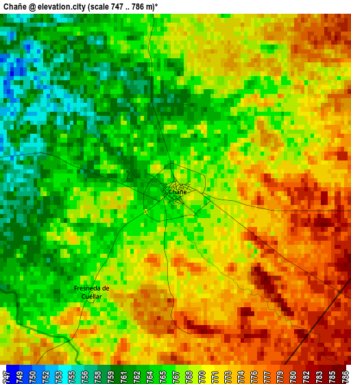
Below is the Elevation map of Chañe, which displays elevation range with different colors. Scale of the first map is from 747 to 786 m (2451 to 2579 ft) with average elevation of 768.4 meters (=2521 ft) [note 1]
These maps also provides idea of topography and contour of this city, they are displayed at different zoom levels. More info about maps, scale and edge coordinates you can find below images.
| \ | Map #1 | Topo.Map |
| Scale [m] | 747..786 m | × |
| Scale [ft] | 2451..2579 ft | × |
| Average | 768.4 m = 2521 ft | × |
| Width | 7.34 km = 4.6 mi | 234.8 km = 145.9 mi |
| Height | 7.34 km = 4.6 mi | 234.8 km = 145.9 mi |
| ↑Max Latitude | 41.371327° | 42.38561° |
| Latitude at center | 41.33834° | 41.33834° |
| ↓Min Latitude | 41.305337° | 40.27395° |
| ← Min Longitude | -4.471585° | -5.83389° |
| Longitude center | -4.42764° | -4.42764° |
| →Max Longitude | -4.383695° | -3.02139° |
Nearby cities:
Cities around Chañe sort by population:
• Cuéllar elevation 872 m
11.8 km,  53°
53°
• Iscar 755 m
9.2 km,  286°
286°
• Pedrajas de San Esteban 754 m
12.9 km,  271°
271°
• Sanchonuño 807 m
10.4 km,  99°
99°
• Vallelado 778 m
7.3 km,  0°
0°
• San Miguel del Arroyo 817 m
12 km,  347°
347°
• Samboal 795 m
9 km,  174°
174°
• Viloria 877 m
12.5 km,  17°
17°
• Remondo 756 m
4.7 km, 273°
• Mata de Cuéllar 753 m
7.4 km,  330°
330°
• Fresneda de Cuéllar 767 m
2.8 km,  220°
220°
• San Cristóbal de Cuéllar 809 m
7.8 km,  14°
14°
Multilingual:
 En español:
Chañe elevación 768 m.
 En France:
Chañe élévation 768 m.


Sources and notes:
- [note 1] Map square and city borders are not equal. Map elevation data is calculated only from area inside that square.
- [src 1] Elevation data from geonames database provided with same terms of usage.
- [src 2] The elevation map of Chañe is generated using elevation data from NASA's 3 arcsec (90m) resolution SRTM data.
- [src 3] Base (background) map © OpenStreetMap contributors tiles are generated by Geofabrik and OpenTopoMap.
Copyright & License:
This Chañe Elevation Map is licensed under CC BY-SA. You may reuse any part from this page, if you give a proper credit by linking to this URL:
 More info on terms of use page.