Chinchón elevation
Chinchón (Madrid, Provincia de Madrid), Spain elevation is 742 meters and Chinchón elevation in feet is 2434 ft above sea level [src 1]. Chinchón is a seat of a third-order administrative division (feature code) with elevation that is 139 meters (456 ft) bigger than average city elevation in Spain.
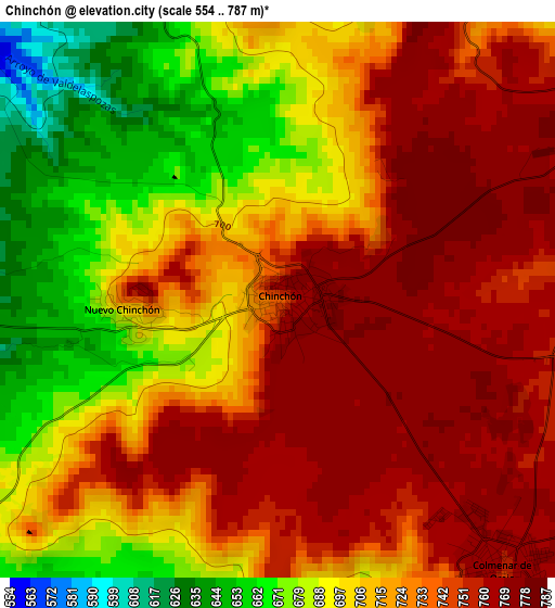
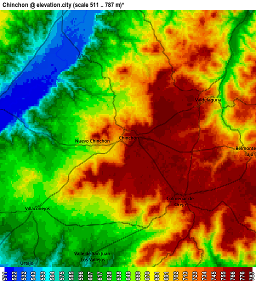
Below is the Elevation map of Chinchón, which displays elevation range with different colors. Scale of the first map is from 554 to 787 m (1818 to 2582 ft) with average elevation of 721.5 meters (=2367 ft) [note 1]
These maps also provides idea of topography and contour of this city, they are displayed at different zoom levels. More info about maps, scale and edge coordinates you can find below images.
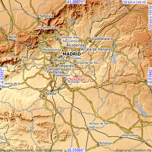
| \ | Map #1 | Map #2 | Topo.Map |
| Scale [m] | 554..787 m | 511..787 m | × |
| Scale [ft] | 1818..2582 ft | 1677..2582 ft | × |
| Average | 721.5 m = 2367 ft | 672.3 m = 2206 ft | × |
| Width | 7.47 km = 4.6 mi | 14.94 km = 9.3 mi | 239.1 km = 148.6 mi |
| Height | 7.47 km = 4.6 mi | 14.94 km = 9.3 mi | 239.1 km = 148.6 mi |
| ↑Max Latitude | 40.173787° | 40.207356° | 41.20671° |
| Latitude at center | 40.1402° | 40.1402° | 40.1402° |
| ↓Min Latitude | 40.106597° | 40.072977° | 39.05668° |
| ← Min Longitude | -3.466615° | -3.510561° | -4.82892° |
| Longitude center | -3.42267° | -3.42267° | -3.42267° |
| →Max Longitude | -3.378725° | -3.334779° | -2.01642° |
Nearby cities:
Cities around Chinchón sort by population:
• Ciempozuelos elevation 585 m
17 km,  277°
277°
• San Martín de la Vega 518 m
14.6 km,  300°
300°
• Colmenar de Oreja 763 m
4.9 km,  139°
139°
• Villarejo de Salvanés 755 m
13.1 km,  77°
77°
• Morata de Tajuña 550 m
9.7 km,  354°
354°
• Villaconejos 635 m
6.7 km,  229°
229°
• Villarrubia de Santiago 758 m
17.8 km,  165°
165°
• Perales de Tajuña 582 m
11.9 km,  31°
31°
• Tielmes 599 m
15 km,  37°
37°
• Belmonte de Tajo 726 m
7.4 km,  97°
97°
• Titulcia 508 m
12.3 km,  267°
267°
• Villamanrique de Tajo 533 m
17.8 km,  117°
117°
Multilingual:
 En español:
Chinchón elevación 742 m.
 En France:
Chinchón élévation 742 m.
 Auf Deutsch:
Chinchón höhe über dem Meeresspiegel ist 742 m.

Sources and notes:
- [note 1] Map square and city borders are not equal. Map elevation data is calculated only from area inside that square.
- [src 1] Elevation data from geonames database provided with same terms of usage.
- [src 2] The elevation map of Chinchón is generated using elevation data from NASA's 3 arcsec (90m) resolution SRTM data.
- [src 3] Base (background) map © OpenStreetMap contributors tiles are generated by Geofabrik and OpenTopoMap.
Copyright & License:
This Chinchón Elevation Map is licensed under CC BY-SA. You may reuse any part from this page, if you give a proper credit by linking to this URL:
 More info on terms of use page.