Ciadoncha elevation
Ciadoncha (Castille and León, Provincia de Burgos), Spain elevation is 792 meters and Ciadoncha elevation in feet is 2598 ft above sea level [src 1]. Ciadoncha is a seat of a third-order administrative division (feature code) with elevation that is 189 meters (620 ft) bigger than average city elevation in Spain.
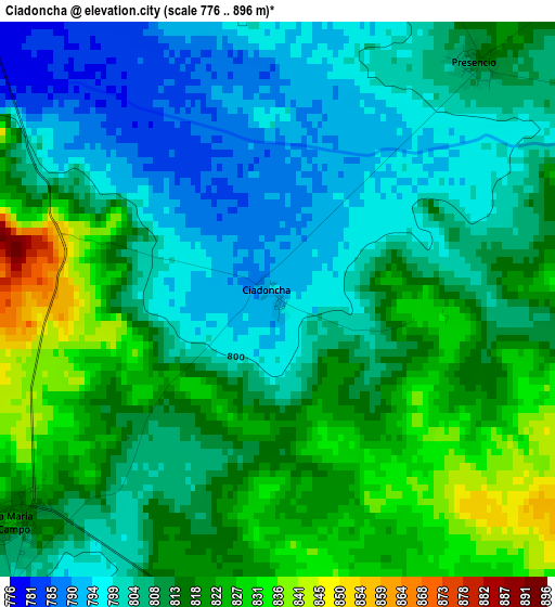
Below is the Elevation map of Ciadoncha, which displays elevation range with different colors. Scale of the first map is from 776 to 896 m (2546 to 2940 ft) with average elevation of 810.6 meters (=2659 ft) [note 1]
These maps also provides idea of topography and contour of this city, they are displayed at different zoom levels. More info about maps, scale and edge coordinates you can find below images.
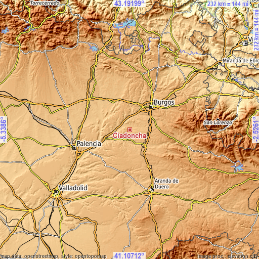
| \ | Map #1 | Topo.Map |
| Scale [m] | 776..896 m | × |
| Scale [ft] | 2546..2940 ft | × |
| Average | 810.6 m = 2659 ft | × |
| Width | 7.24 km = 4.5 mi | 231.8 km = 144 mi |
| Height | 7.24 km = 4.5 mi | 231.8 km = 144 mi |
| ↑Max Latitude | 42.190708° | 43.19199° |
| Latitude at center | 42.15814° | 42.15814° |
| ↓Min Latitude | 42.125555° | 41.10712° |
| ← Min Longitude | -3.976295° | -5.3386° |
| Longitude center | -3.93235° | -3.93235° |
| →Max Longitude | -3.888405° | -2.5261° |
Nearby cities:
Cities around Ciadoncha sort by population:
• Santa María del Campo elevation 813 m
4.4 km,  230°
230°
• Pampliega 815 m
6.9 km,  319°
319°
• Villahoz 832 m
9.3 km,  170°
170°
• Presencio 814 m
4.1 km,  38°
38°
• Villaverde del Monte 849 m
9.7 km,  88°
88°
• Mahamud 830 m
4.3 km,  189°
189°
• Belbimbre 796 m
6.7 km,  280°
280°
• Villazopeque 782 m
8.3 km,  302°
302°
• Mazuela 826 m
5.6 km,  11°
11°
• Olmillos de Muñó 812 m
5 km,  353°
353°
• Barrio de Muñó 775 m
6.5 km,  287°
287°
• Palazuelos de Muñó 784 m
6.4 km,  312°
312°
Multilingual:
 En español:
Ciadoncha elevación 792 m.
 En France:
Ciadoncha élévation 792 m.
 Auf Deutsch:
Ciadoncha höhe über dem Meeresspiegel ist 792 m.

Sources and notes:
- [note 1] Map square and city borders are not equal. Map elevation data is calculated only from area inside that square.
- [src 1] Elevation data from geonames database provided with same terms of usage.
- [src 2] The elevation map of Ciadoncha is generated using elevation data from NASA's 3 arcsec (90m) resolution SRTM data.
- [src 3] Base (background) map © OpenStreetMap contributors tiles are generated by Geofabrik and OpenTopoMap.
Copyright & License:
This Ciadoncha Elevation Map is licensed under CC BY-SA. You may reuse any part from this page, if you give a proper credit by linking to this URL:
 More info on terms of use page.