Cirueña elevation
Cirueña (La Rioja, Provincia de La Rioja), Spain elevation is 745 meters and Cirueña elevation in feet is 2444 ft above sea level [src 1]. Cirueña is a seat of a third-order administrative division (feature code) with elevation that is 142 meters (466 ft) bigger than average city elevation in Spain.
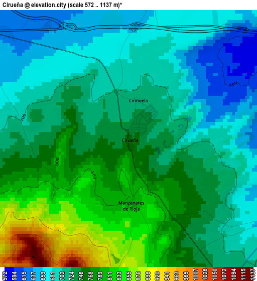
Below is the Elevation map of Cirueña, which displays elevation range with different colors. Scale of the first map is from 572 to 1137 m (1877 to 3730 ft) with average elevation of 734.6 meters (=2410 ft) [note 1]
These maps also provides idea of topography and contour of this city, they are displayed at different zoom levels. More info about maps, scale and edge coordinates you can find below images.
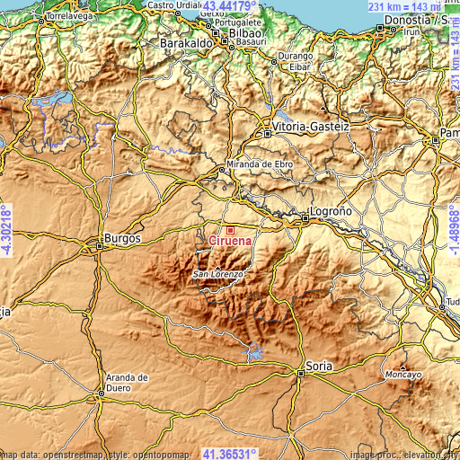
| \ | Map #1 | Topo.Map |
| Scale [m] | 572..1137 m | × |
| Scale [ft] | 1877..3730 ft | × |
| Average | 734.6 m = 2410 ft | × |
| Width | 7.22 km = 4.5 mi | 230.9 km = 143.5 mi |
| Height | 7.22 km = 4.5 mi | 230.9 km = 143.5 mi |
| ↑Max Latitude | 42.444577° | 43.44179° |
| Latitude at center | 42.41214° | 42.41214° |
| ↓Min Latitude | 42.379686° | 41.36531° |
| ← Min Longitude | -2.939875° | -4.30218° |
| Longitude center | -2.89593° | -2.89593° |
| →Max Longitude | -2.851985° | -1.48968° |
Nearby cities:
Cities around Cirueña sort by population:
• Santo Domingo de la Calzada elevation 646 m
5.7 km,  303°
303°
• Alesanco 565 m
6.5 km,  88°
88°
• Bañares 597 m
6.4 km,  349°
349°
• Villar de Torre 758 m
5.2 km,  150°
150°
• Cordovín 596 m
7.3 km,  113°
113°
• Santurdejo 784 m
6.2 km,  230°
230°
• Cañas 641 m
4.6 km,  118°
118°
• Hervías 646 m
4 km,  10°
10°
• Manzanares de Rioja 803 m
1.8 km,  179°
179°
• Torrecilla sobre Alesanco 614 m
5.1 km, 94°
• Villarejo 828 m
4.3 km,  170°
170°
• Canillas de Río Tuerto 624 m
4.7 km, 107°
Multilingual:
 En español:
Cirueña elevación 745 m.
 En France:
Cirueña élévation 745 m.


Sources and notes:
- [note 1] Map square and city borders are not equal. Map elevation data is calculated only from area inside that square.
- [src 1] Elevation data from geonames database provided with same terms of usage.
- [src 2] The elevation map of Cirueña is generated using elevation data from NASA's 3 arcsec (90m) resolution SRTM data.
- [src 3] Base (background) map © OpenStreetMap contributors tiles are generated by Geofabrik and OpenTopoMap.
Copyright & License:
This Cirueña Elevation Map is licensed under CC BY-SA. You may reuse any part from this page, if you give a proper credit by linking to this URL:
 More info on terms of use page.