Coca elevation
Coca (Castille and León, Provincia de Segovia), Spain elevation is 789 meters and Coca elevation in feet is 2589 ft above sea level [src 1]. Coca is a seat of a third-order administrative division (feature code) with elevation that is 186 meters (610 ft) bigger than average city elevation in Spain.
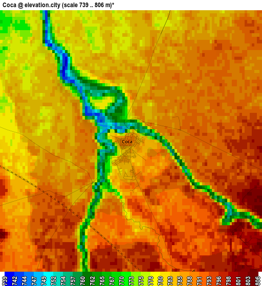
Below is the Elevation map of Coca, which displays elevation range with different colors. Scale of the first map is from 739 to 806 m (2425 to 2644 ft) with average elevation of 785.9 meters (=2578 ft) [note 1]
These maps also provides idea of topography and contour of this city, they are displayed at different zoom levels. More info about maps, scale and edge coordinates you can find below images.
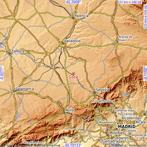
| \ | Map #1 | Topo.Map |
| Scale [m] | 739..806 m | × |
| Scale [ft] | 2425..2644 ft | × |
| Average | 785.9 m = 2578 ft | × |
| Width | 7.35 km = 4.6 mi | 235.2 km = 146.1 mi |
| Height | 7.35 km = 4.6 mi | 235.2 km = 146.1 mi |
| ↑Max Latitude | 41.250718° | 42.2669° |
| Latitude at center | 41.21767° | 41.21767° |
| ↓Min Latitude | 41.184605° | 40.15133° |
| ← Min Longitude | -4.565395° | -5.9277° |
| Longitude center | -4.52145° | -4.52145° |
| →Max Longitude | -4.477505° | -3.1152° |
Nearby cities:
Cities around Coca sort by population:
• Nava de la Asunción elevation 809 m
7.4 km,  157°
157°
• Navas de Oro 808 m
7.4 km,  108°
108°
• Santiuste de San Juan Bautista 821 m
8.1 km,  211°
211°
• Samboal 795 m
9.8 km,  63°
63°
• Fresneda de Cuéllar 767 m
12.8 km,  28°
28°
• Fuente de Santa Cruz 834 m
9.6 km,  264°
264°
• Villeguillo 771 m
6.2 km,  308°
308°
• Bocigas 773 m
13.4 km,  276°
276°
• Llano de Olmedo 781 m
9.5 km, 305°
• Puras 803 m
11.4 km,  250°
250°
• Almenara de Adaja 780 m
13.1 km,  268°
268°
• Aguasal 755 m
12.7 km,  300°
300°
Multilingual:
 En español:
Coca elevación 789 m.
 En France:
Coca élévation 789 m.


Sources and notes:
- [note 1] Map square and city borders are not equal. Map elevation data is calculated only from area inside that square.
- [src 1] Elevation data from geonames database provided with same terms of usage.
- [src 2] The elevation map of Coca is generated using elevation data from NASA's 3 arcsec (90m) resolution SRTM data.
- [src 3] Base (background) map © OpenStreetMap contributors tiles are generated by Geofabrik and OpenTopoMap.
Copyright & License:
This Coca Elevation Map is licensed under CC BY-SA. You may reuse any part from this page, if you give a proper credit by linking to this URL:
 More info on terms of use page.