Codos elevation
Codos (Aragon, Provincia de Zaragoza), Spain elevation is 751 meters and Codos elevation in feet is 2464 ft above sea level [src 1]. Codos is a seat of a third-order administrative division (feature code) with elevation that is 148 meters (486 ft) bigger than average city elevation in Spain.
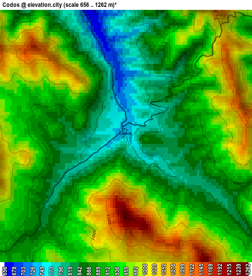
Below is the Elevation map of Codos, which displays elevation range with different colors. Scale of the first map is from 656 to 1262 m (2152 to 4140 ft) with average elevation of 918.9 meters (=3015 ft) [note 1]
These maps also provides idea of topography and contour of this city, they are displayed at different zoom levels. More info about maps, scale and edge coordinates you can find below images.
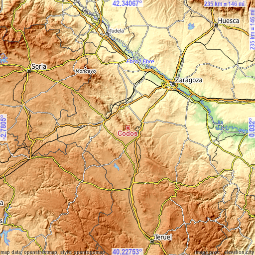
| \ | Map #1 | Topo.Map |
| Scale [m] | 656..1262 m | × |
| Scale [ft] | 2152..4140 ft | × |
| Average | 918.9 m = 3015 ft | × |
| Width | 7.34 km = 4.6 mi | 235 km = 146 mi |
| Height | 7.34 km = 4.6 mi | 235 km = 146 mi |
| ↑Max Latitude | 41.32567° | 42.34067° |
| Latitude at center | 41.29266° | 41.29266° |
| ↓Min Latitude | 41.259633° | 40.22753° |
| ← Min Longitude | -1.418195° | -2.7805° |
| Longitude center | -1.37425° | -1.37425° |
| →Max Longitude | -1.330305° | 0.032° |
Nearby cities:
Cities around Codos sort by population:
• Almonacid de la Sierra elevation 604 m
12.4 km,  19°
19°
• Aguarón 644 m
10.1 km,  59°
59°
• Cosuenda 623 m
10.3 km,  37°
37°
• Encinacorba 754 m
8.3 km,  95°
95°
• Tobed 650 m
5.5 km,  337°
337°
• Santa Cruz de Grío 640 m
9.8 km,  331°
331°
• Mara 697 m
12 km,  268°
268°
• Langa del Castillo 881 m
9.2 km,  192°
192°
• Mainar 870 m
12.6 km,  151°
151°
• Orera 754 m
8.7 km, 274°
• Ruesca 773 m
9 km,  263°
263°
• Torralbilla 888 m
9.7 km,  161°
161°
Multilingual:
 En español:
Codos elevación 751 m.
 En France:
Codos élévation 751 m.


Sources and notes:
- [note 1] Map square and city borders are not equal. Map elevation data is calculated only from area inside that square.
- [src 1] Elevation data from geonames database provided with same terms of usage.
- [src 2] The elevation map of Codos is generated using elevation data from NASA's 3 arcsec (90m) resolution SRTM data.
- [src 3] Base (background) map © OpenStreetMap contributors tiles are generated by Geofabrik and OpenTopoMap.
Copyright & License:
This Codos Elevation Map is licensed under CC BY-SA. You may reuse any part from this page, if you give a proper credit by linking to this URL:
 More info on terms of use page.