Colunga elevation
Colunga (Asturias, Province of Asturias), Spain elevation is 17 meters and Colunga elevation in feet is 56 ft above sea level [src 1]. Colunga is a seat of a third-order administrative division (feature code) with elevation that is 586 meters (1923 ft) smaller than average city elevation in Spain.
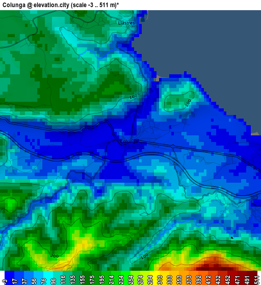
Below is the Elevation map of Colunga, which displays elevation range with different colors. Scale of the first map is from -3 to 511 m (-10 to 1677 ft) with average elevation of 102.8 meters (=337 ft) [note 1]
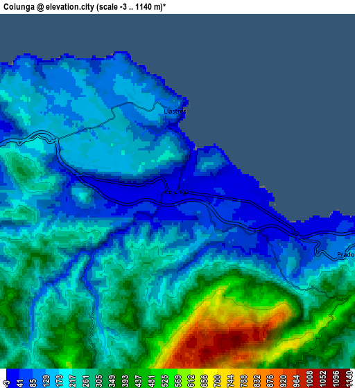
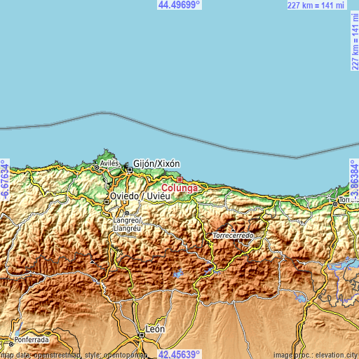
These maps also provides idea of topography and contour of this city, they are displayed at different zoom levels. More info about maps, scale and edge coordinates you can find below images.
| \ | Map #1 | Map #2 | Topo.Map |
| Scale [m] | -3..511 m | -3..1140 m | × |
| Scale [ft] | -10..1677 ft | -10..3740 ft | × |
| Average | 102.8 m = 337 ft | 238.9 m = 784 ft | × |
| Width | 7.09 km = 4.4 mi | 14.18 km = 8.8 mi | 226.9 km = 141 mi |
| Height | 7.09 km = 4.4 mi | 14.18 km = 8.8 mi | 226.9 km = 141 mi |
| ↑Max Latitude | 43.517186° | 43.549045° | 44.49699° |
| Latitude at center | 43.48531° | 43.48531° | 43.48531° |
| ↓Min Latitude | 43.453417° | 43.421507° | 42.45639° |
| ← Min Longitude | -5.314035° | -5.357981° | -6.67634° |
| Longitude center | -5.27009° | -5.27009° | -5.27009° |
| →Max Longitude | -5.226145° | -5.182199° | -3.86384° |
Nearby cities:
Cities around Colunga sort by population:
• Gijón elevation 22 m
32.1 km,  280°
280°
• Villaviciosa 6 m
13.4 km,  268°
268°
• Piloña 168 m
16.9 km,  207°
207°
• Cangas de Onís 60 m
18.7 km,  142°
142°
• Ribadesella 20 m
17.2 km,  98°
98°
• Parres 125 m
17.9 km,  147°
147°
• Arriba 150 m
21.6 km, 279°
• Bimenes 587 m
29.4 km,  230°
230°
• Sariego 304 m
23.3 km,  245°
245°
• Santa Eulalia 234 m
13.7 km,  236°
236°
• Amieva 599 m
31.1 km, 149°
• Nava 260 m
24 km, 233°
Multilingual:
 En español:
Colunga elevación 17 m.
 En France:
Colunga élévation 17 m.


Sources and notes:
- [note 1] Map square and city borders are not equal. Map elevation data is calculated only from area inside that square.
- [src 1] Elevation data from geonames database provided with same terms of usage.
- [src 2] The elevation map of Colunga is generated using elevation data from NASA's 3 arcsec (90m) resolution SRTM data.
- [src 3] Base (background) map © OpenStreetMap contributors tiles are generated by Geofabrik and OpenTopoMap.
Copyright & License:
This Colunga Elevation Map is licensed under CC BY-SA. You may reuse any part from this page, if you give a proper credit by linking to this URL:
 More info on terms of use page.