Derio elevation
Derio (Basque Country, Bizkaia), Spain elevation is 58 meters and Derio elevation in feet is 190 ft above sea level [src 1]. Derio is a seat of a third-order administrative division (feature code) with elevation that is 545 meters (1788 ft) smaller than average city elevation in Spain.
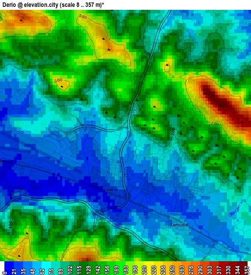
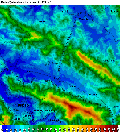
Below is the Elevation map of Derio, which displays elevation range with different colors. Scale of the first map is from 8 to 357 m (26 to 1171 ft) with average elevation of 105.2 meters (=345 ft) [note 1]
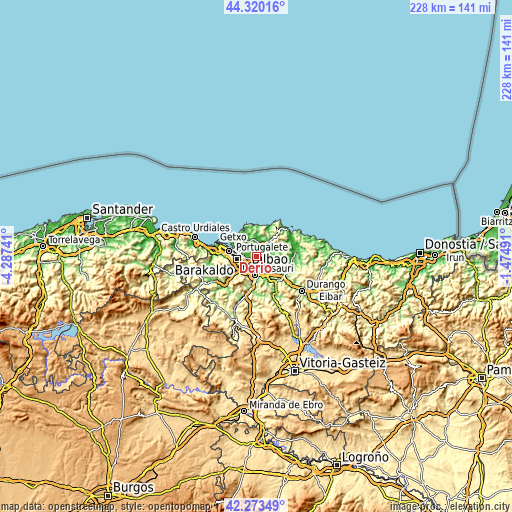
These maps also provides idea of topography and contour of this city, they are displayed at different zoom levels. More info about maps, scale and edge coordinates you can find below images.
| \ | Map #1 | Map #2 | Topo.Map |
| Scale [m] | 8..357 m | -5..470 m | × |
| Scale [ft] | 26..1171 ft | -16..1542 ft | × |
| Average | 105.2 m = 345 ft | 105.6 m = 346 ft | × |
| Width | 7.11 km = 4.4 mi | 14.22 km = 8.8 mi | 227.6 km = 141.4 mi |
| Height | 7.11 km = 4.4 mi | 14.22 km = 8.8 mi | 227.6 km = 141.4 mi |
| ↑Max Latitude | 43.337411° | 43.369365° | 44.32016° |
| Latitude at center | 43.30544° | 43.30544° | 43.30544° |
| ↓Min Latitude | 43.273452° | 43.241448° | 42.27349° |
| ← Min Longitude | -2.925105° | -2.969051° | -4.28741° |
| Longitude center | -2.88116° | -2.88116° | -2.88116° |
| →Max Longitude | -2.837215° | -2.793269° | -1.47491° |
Nearby cities:
Cities around Derio sort by population:
• Bilbao elevation 20 m
5.9 km,  216°
216°
• Barakaldo 27 m
8.7 km,  263°
263°
• Santutxu 78 m
6.4 km,  206°
206°
• Basauri 57 m
7.3 km,  182°
182°
• Leioa 24 m
9 km,  285°
285°
• Galdakao 65 m
8.9 km,  159°
159°
• Erandio 9 m
7.5 km,  269°
269°
• Mungia 36 m
6.2 km,  27°
27°
• Zamudio 45 m
2.3 km, 157°
• Zaratamo 153 m
9.9 km,  173°
173°
• Gatika 78 m
6.4 km,  5°
5°
• Sondika 27 m
3.5 km, 260°
Multilingual:
 En español:
Derio elevación 58 m.
 En France:
Derio élévation 58 m.


Sources and notes:
- [note 1] Map square and city borders are not equal. Map elevation data is calculated only from area inside that square.
- [src 1] Elevation data from geonames database provided with same terms of usage.
- [src 2] The elevation map of Derio is generated using elevation data from NASA's 3 arcsec (90m) resolution SRTM data.
- [src 3] Base (background) map © OpenStreetMap contributors tiles are generated by Geofabrik and OpenTopoMap.
Copyright & License:
This Derio Elevation Map is licensed under CC BY-SA. You may reuse any part from this page, if you give a proper credit by linking to this URL:
 More info on terms of use page.